Read the full blog and view photo albumand videoshere.
Friday 5th January 2024
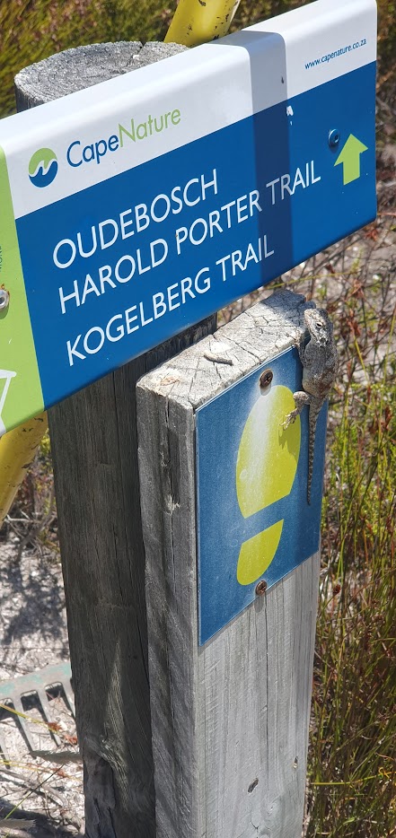
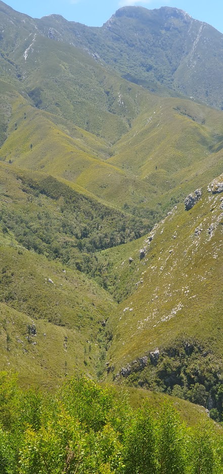
My friend, Ralph Pina, whom I have known since schooldays, suggested a hike in the Kogelberg Nature Reserve, when I paid them a visit in Rooi Els, located along the coastal R44 from Gordon’s Bay, east of Cape Town. The road is subject to a number of stop and go’s in places, owing to damage suffered as a result of it being washed away during heavy winter rainfalls. The plan in terms of a walk was to do the Oudebosch to Harold Porter Botanical Gardens Trail however after another local resident pulled out, a change of plan was required, given that a vehicle was parked at one end only.
The trail starts at the Cape Nature offices located a couple of kilometres into the park. A permit is required for the walk but Ralph had a wild card registered for two. For the first part, the 7.2km Oudebosch to Harold Porter Trail shares the route with the 22.9 Kogelberg circular route which Ralph and I had done before a number of years ago. The trail heads away from the Palmiet River past the ecologically-designed cabins that serve an up-market clientelle. The construction of a new eco- office complex and improvements to the jeep track into the reserve suggest a significant investment since my last visit. The parking area appeared full, suggesting that all the cabins were fully booked.
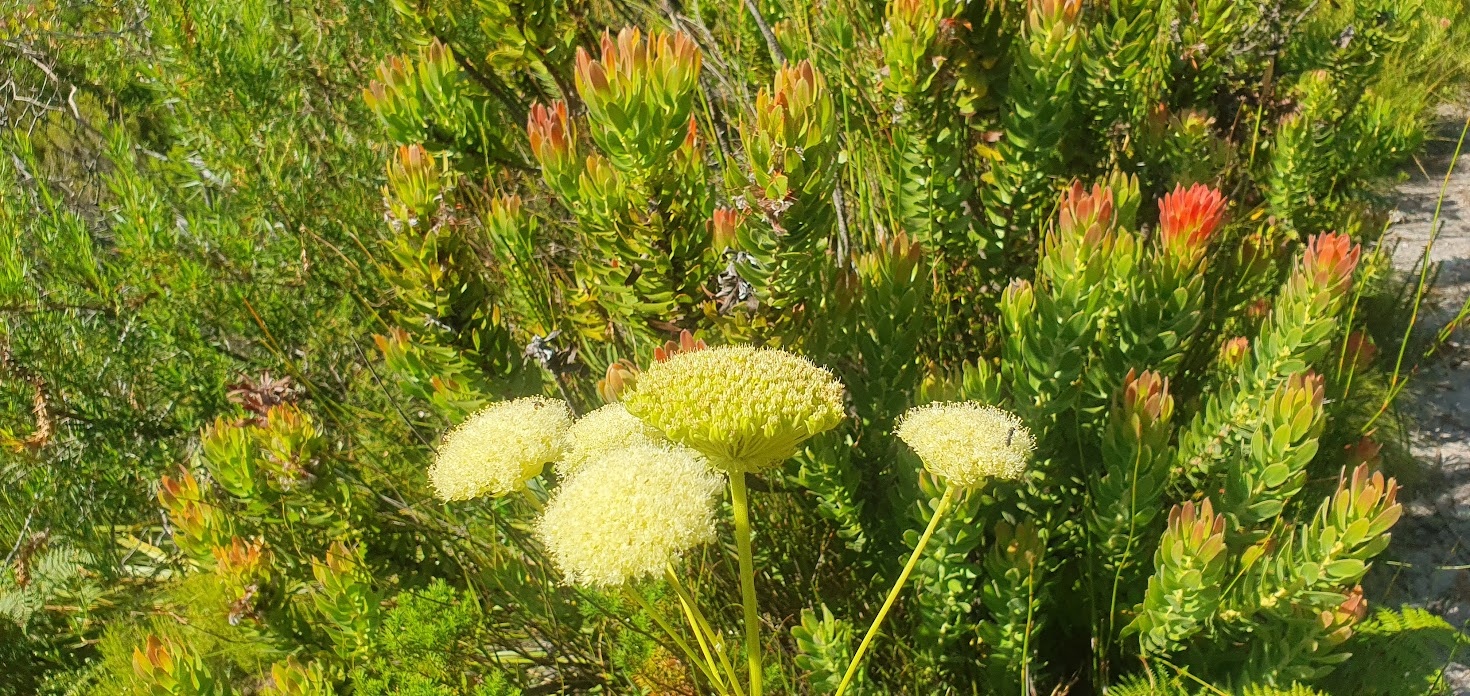
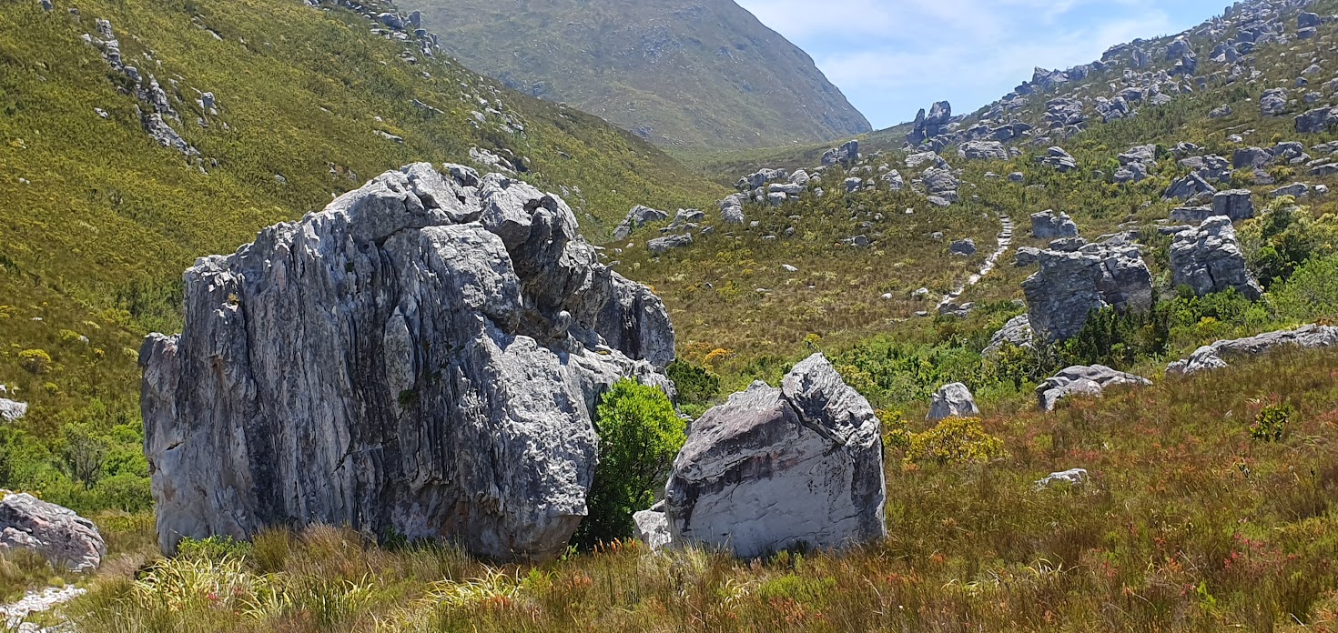
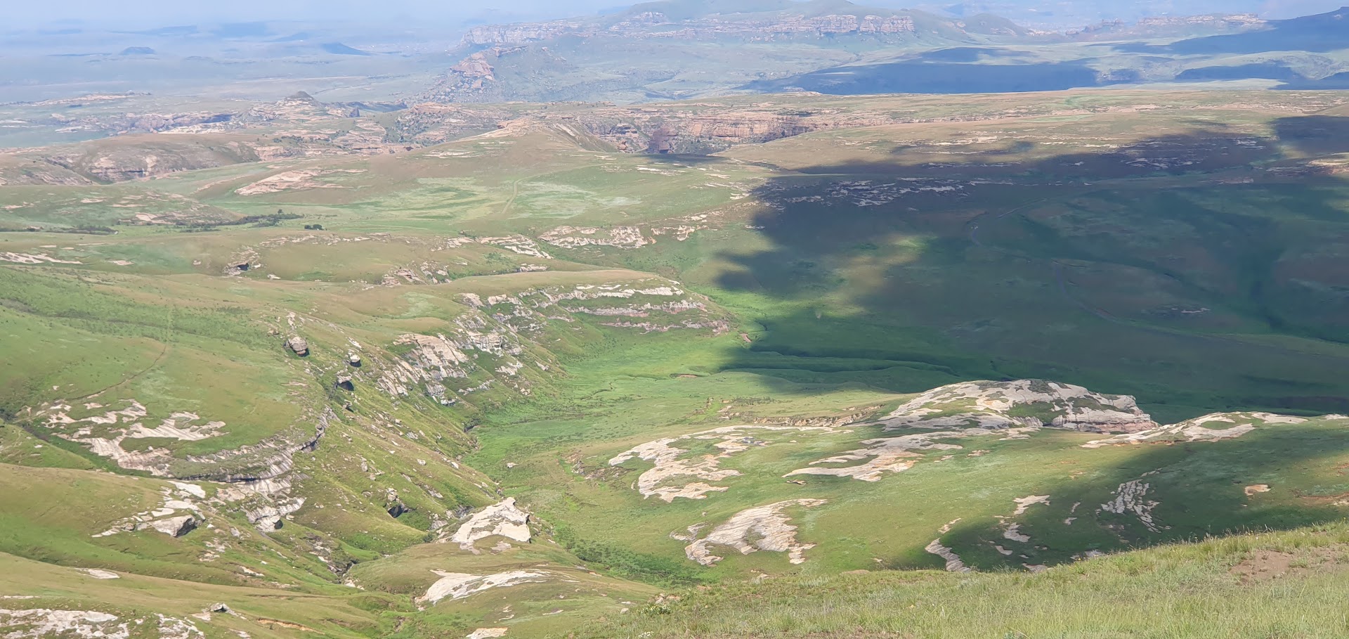
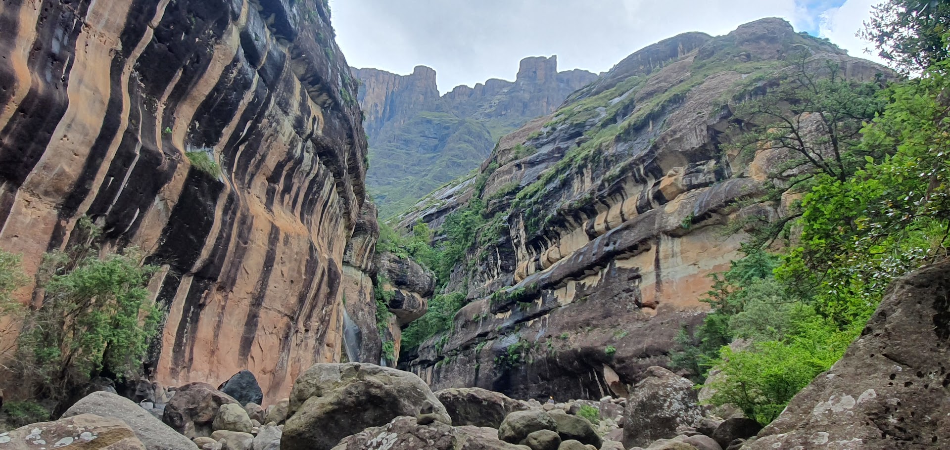
The path heads up the valley towards a nek that is naturally forested with indigenous trees, predominantly yellowwood, offering shelter from humidity and heat. The landscape is unspoilt and rich in fynbos. After emerging from the forest, where we doused our headgear in cold water from a stream, the path climbs as it crosses the stream before splitting into the two trails referred to. We reached the highest point on the shorter trail, where a wooden deck provides an opportunity of catching a first glimpse of the coastline in the distance. The path then drops down the slope until one reaches the top of a huge, steep gorge and waterfall, with vistas of Harold Porter and the Betty’s Bay coastline. At this juncture, owing to logistics, we had decided to return back along the same route to the Kogelberg offices.
Kogelberg Nature Reserve, east of Cape Town, is a nature reserve of 3,000 ha comprising the Kogelberg Mountain Range. With about 1600 plant species, it contains a floral diversity per unit area that is greater than anywhere else in the world.
The nature reserve forms the “core conservation area” within the 1,000-square-kilometre Kogelberg Biosphere Reserve. As such, the nature reserve is surrounded by buffer zones of natural vegetation and environmentally friendly recreational areas, as well as transitional zones of environmentally aware farms and towns.
Read the full blog and view photo albumand videoshere.
Read the full blog and view photo albumand videoshere.
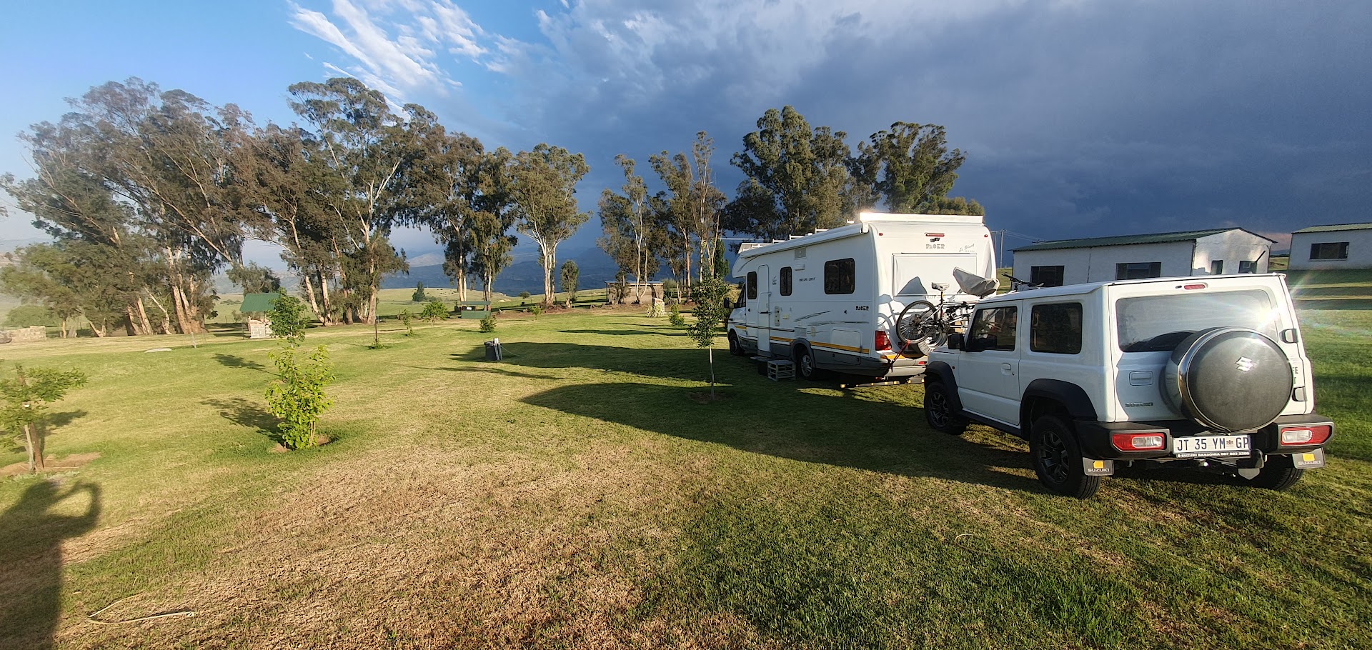
My annual holiday to South Africa produced an unexpected twist during the planning stage, when my eldest brother and his wife, based at Harbour Town, Vaal Marina, asked if I would consider a stopover. I agreed on one condition, that they take me to the Drakensberg, the highest mountain range in South Africa, on the border with the landlocked Lesotho. Their lifestyle changed when they acquired a campervan to undertake regular trips around South Africa.
Rather than fly to Cape Town, it was suggested that we drive down in the campervan. Over a matter of weeks, an itinerary took shape, incorporating three days in the Drakensberg and two at Golden Gate National Park (near Clarens), where I hoped to do some walks, before driving via Bloemfontein and Graaff Reinet to Knysna, located on the Garden Route in the Eastern Cape. The final leg along the coast to the Mother City would incorporate stops in Mossel Bay and Hermanus, a total journey lasting two weeks.
Read the individual blogs and view the full photo albums and videos via the links below.
Read the full blog and view photo albumand videoshere.
Wednesday 20th December– Mossel Bay to Hermanus
After joining my eldest brother Edward and his wife Elna on a two-week campervan trip through South Africa which started at the Drakensberg, our little adventure was now rapidly drawing to a close. Having overnighted near Hartenbos in Mossel Bay at the home of a friend of Elna’s by the name of Monika, once the Jimney was hooked up, we were ready to leave around 08h30.
It’s a three and a quarter hour journey to Hermanus via Riversdale and Swellendam via miles and miles of wheat farming countryside, eventually branching off along the R326 just after Riviersonderend, to take us to the coast once more at Hermanus. I had fallen in love with Swellendam, a town of historical significance and fine Cape Dutch architecture, many years ago. This resulted in my acquiring a plot on a local church auction in town but had never realised the dream of building a home there.
Our arrival at the coast would be put off by a mere hour, owing a prior arrangement to visit the parents of my sister-in-law and wife of my brother Gordon, in Heidelberg, which lies east of Swellendam. Andries and Aletta Wichmann have lived a simple but happy life there for thirty years since his retirement on the railways. Water drawn from a canal running past the back of their property allowed Dries to cultivate a huge fruit and vegetable garden, whilst Aletta’s passion to while away the time in her little workshop, has resulted in her producing the most exquisite leather bags and wallets.
After fuelling the campervan in Swellendam, we drove past the plot I once owned in the hills above the town, above the Dutch Reformed Church. It was no mean feat getting there with the campervan towing a Jimny. I was surprised to see the erf as yet still undeveloped.
Our final stopover of the tour, in Hermanus, involved yet another private arrangement. The parents of Elna’s friends own the Marine Guesthouse on Kus Road. We parked in a field next to the establishment and hooked up to a power-point in a downstairs utility room which contained a bath with hand-shower which proved quite convenient.
That evening we were invited to the home of the parents and actual owners of the guesthouse, located at Lakewood Village within the Fernkloof Golfing Estate but not before we did our own walkabout of the Hermanus town centre near the old harbour. Having last visited Hermanus several decades ago, I barely recognised the place, given the amount of development that has since taken place. I remember a weekend away, the first of many, with a girl called Francis, a model from Kraaifontein, when I was in the army. I remember driving along white dirt roads to get to the B&B. Those roads have long since disappeared. The same could probably be said for what was once a fleeting relationship.
Read the full blog and view photo albumand videoshere.
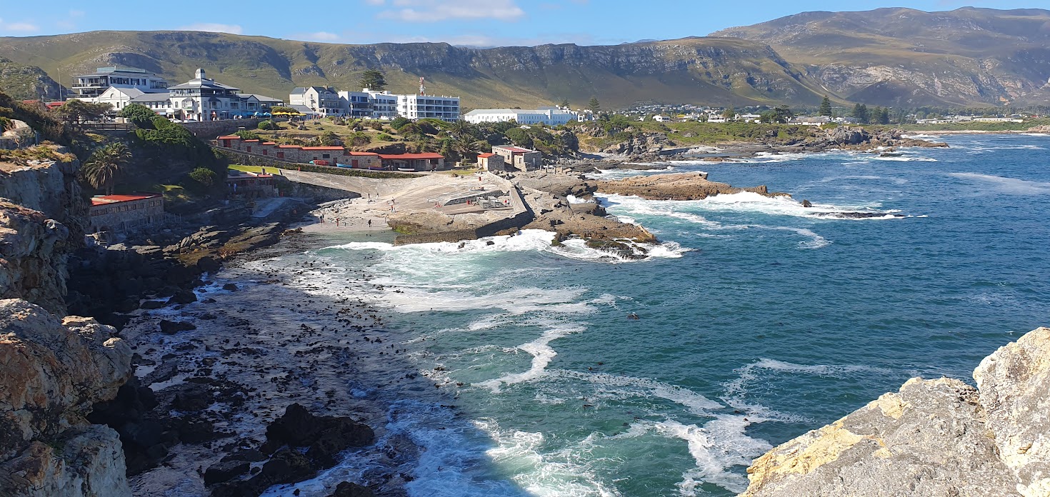
We first walked the beachfront near the old Hermanus harbour. Modern works of art that defy the imagination adorn the walkway at various points. Hermanus is noted for the presence of whales that often swim within sight of the coastline of the town. Although the Southern Right whale is the most prolific species in Hermanus bay, it is not the only species in the area. The whales can be seen from the cliffs all along the coast from as early as June and usually depart in early-December. They were once hunted in the nearby town of Betty’s Bay but are now protected.
It’s no surprise therefore to find a whale museum in the town. The installations and exhibitions at the Whale House Museum are beautifully written with stunning photographs and impressive models. There is a full-size southern right whale skeleton suspended from the ceiling to convey the incredible scale and wonder of these marine mammals. In addition, the sizes of various whales are compared to other animals and humans to create a clear concept of how massive these gentle giants really are.
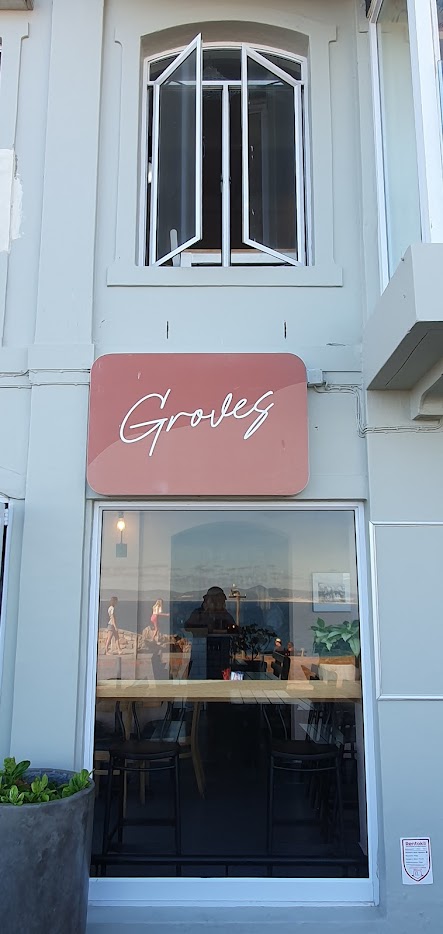
In the course of our Hermanus Waterfront walkabout, the rather unusual Groves Café, being a namesake, caught my eye.
The following anecdotal background to the business appears on their website: “Earlier this year, Groves Café at the Hermanus Waterfront went through an exciting transformation, resulting in a striking new look alongside a completely overhauled menu. Under the ownership of Henri Grové, his son-in-law Lyall Wiggill, and his daughter Leani van Deventer, the establishment has been rebranded as ‘Groves’.
The Grové family is originally from Polokwane, where they ran a successful family restaurant which started in their home. They moved to Somerset West in 2013, leaving the running of the restaurant to family friends, after receiving an opportunity to establish and run the Western Cape branch for Cook4Life – a business which sells high quality, household goods.”
“In 2016, after his wife Pearl passed away, Henri had a dream one night that the owners of Fusion Restaurant wanted to sell. Following his gut, but not yet having the finances, he made the trip to Hermanus to speak to the owners and offered to buy it.
Miraculously, not long after their meeting, Henri received a call from someone wanting to buy their family restaurant and property in Polokwane. Everything fell into place and in 2017, Henri and Lyall moved to Hermanus having purchased Fusion with the shop next door, Bite 2 Eat. A month later, Bite 2 Eat received a complete facelift and ‘Groves Café’ was born in honour of Pearl.”
* * *
From my visit here many decades ago, I recall exploring a cave on the seafront, wondering if this was now the location of Bientangs on the shores of Walker Bay, carved into the depths of a century old cave, in the heart of the best land-based whale watching area in the world.
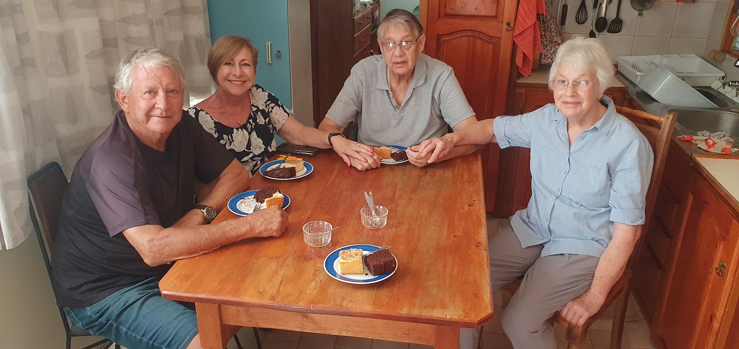
The parking spot Elna had arranged next to the B&B were once again acquaintances, Kobus and Lisa and their two children, from Vaal Marina, where all are based. The invitation to dinner, literally a fish and chip take-away organised by Kobus’s parents, Louis en Jenna, was an unexpected surprise. It turned out be a lovely, sociable evening and I learnt that the parents had lived in London for a year or more where Jenna, an academic, was on sabbatical. Louis is a retiree on the program-side of the South African Broadcasting Corporation (SABC). I could not resist the temptation to ask if he knew radio personalities Michael Meyer and Daryl Jooste, who presented a program called Take a Chance on Saturday mornings, where the pair of them concocted sketches involving various characters, with the two of them doing all the voices. As one of these characters, Wouter Marais, used to say in a thick South African accent “Gracious me, there’s a pip under my denture!”
* * *
Thursday 21st December – The Final Chapter
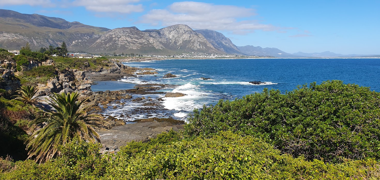
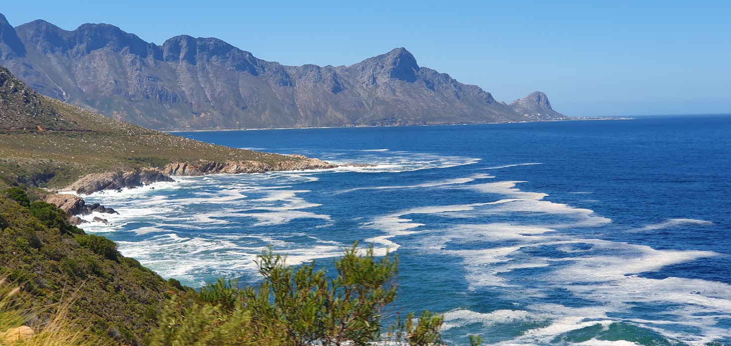
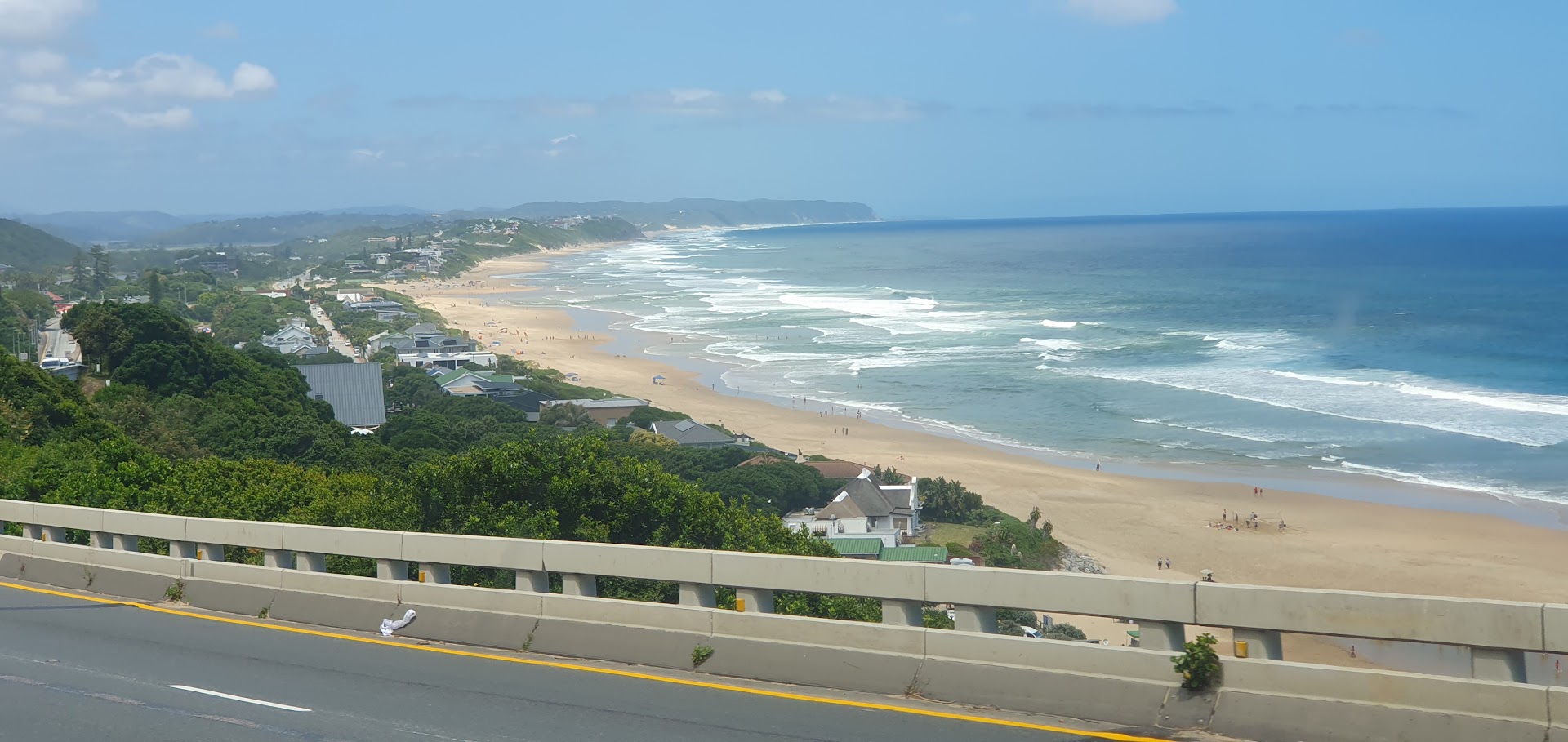
We packed up in Hermanus and found ourselves on the road around 09h00, following the exquisitely beautiful yet familiar route known as Clarence Drive (R44), through Kleinmond, Betty’s Bay, Pringle Bay, Rooi Els, Steenbras, Gordon’s Bay and the Strand arriving around midday at my brother Gordon’s, where I was to spend the next 3 weeks of my holiday. It proved a sudden, anti-climatic end to a journey that will live long in the memory, enabling me to cherish the valuable time spent with my eldest broertjie. The section of the road between Rooi Els and Gordons Bay had been severely damaged by heavy rains and mud slides earlier that year in the winter, which had washed away sections of road, resulting in six stop and go’s being set up and managed on a daily basis.
Read the full blog and view photo albumand videoshere.
* * *
A while later…….
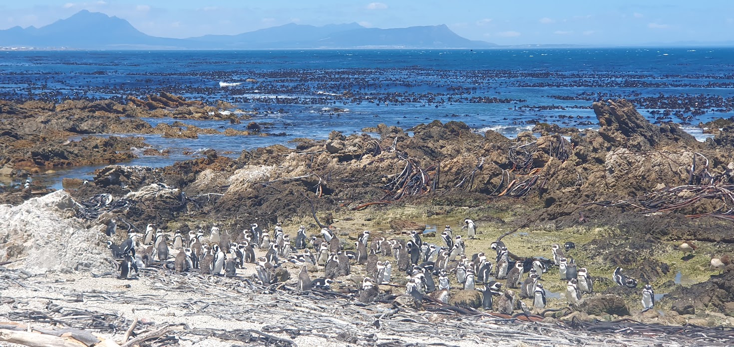
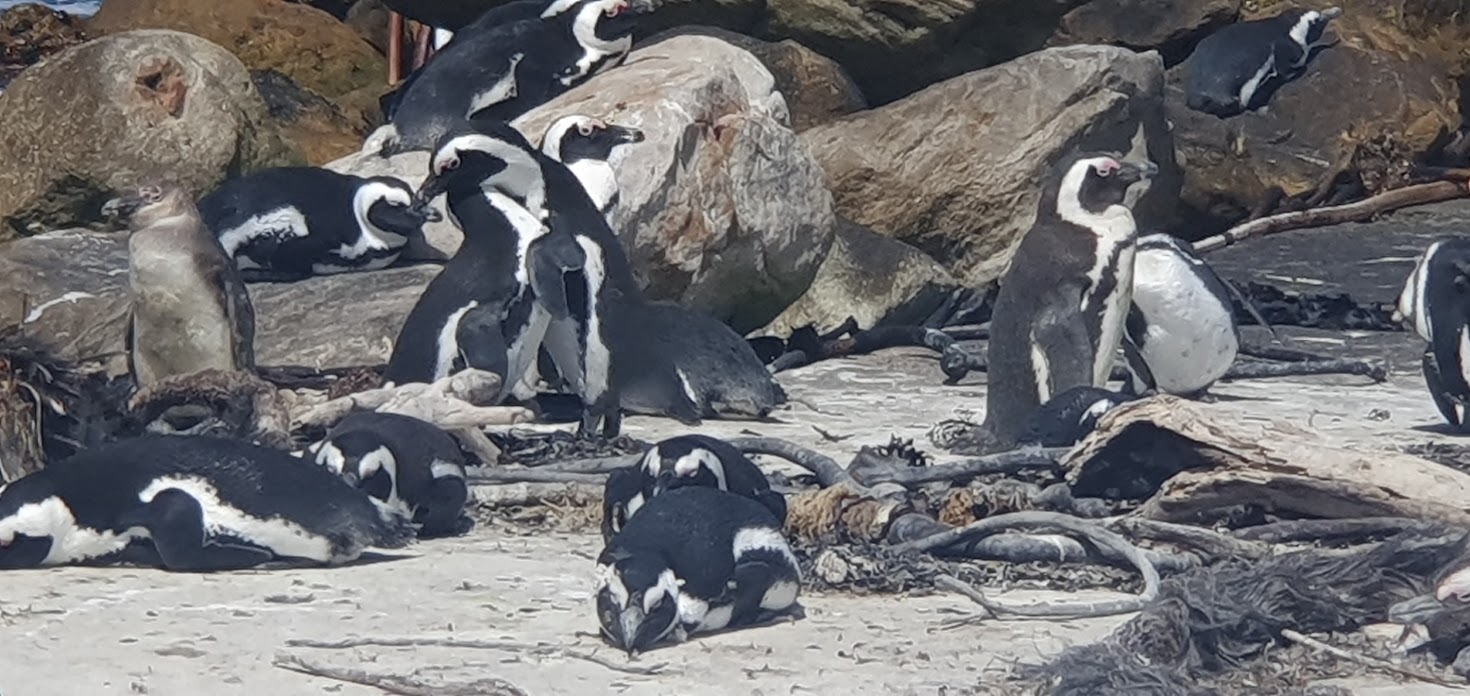
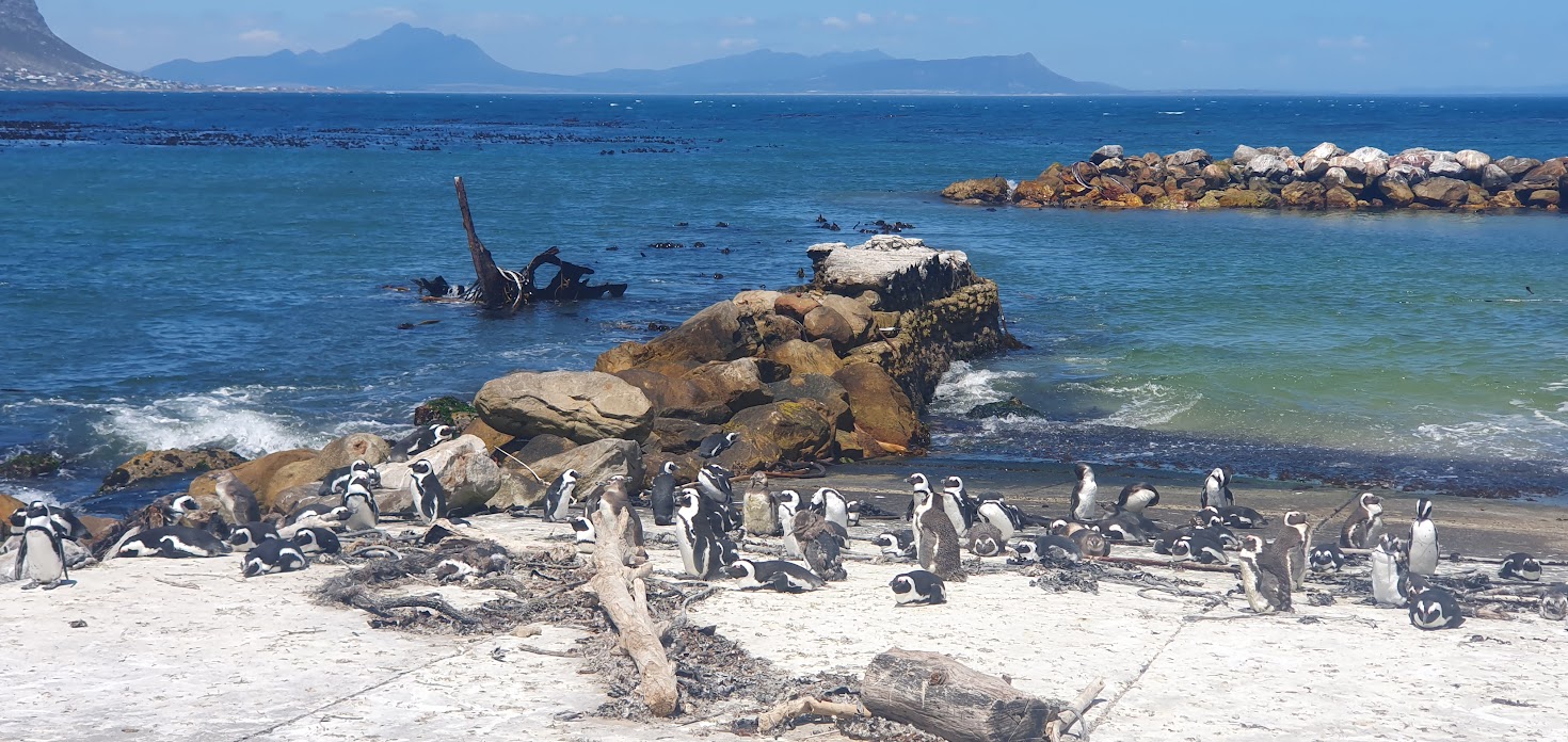
Thursday 21st December – Betty’s Bay’s Stony Point Marine Protected Area and Penguin Walk
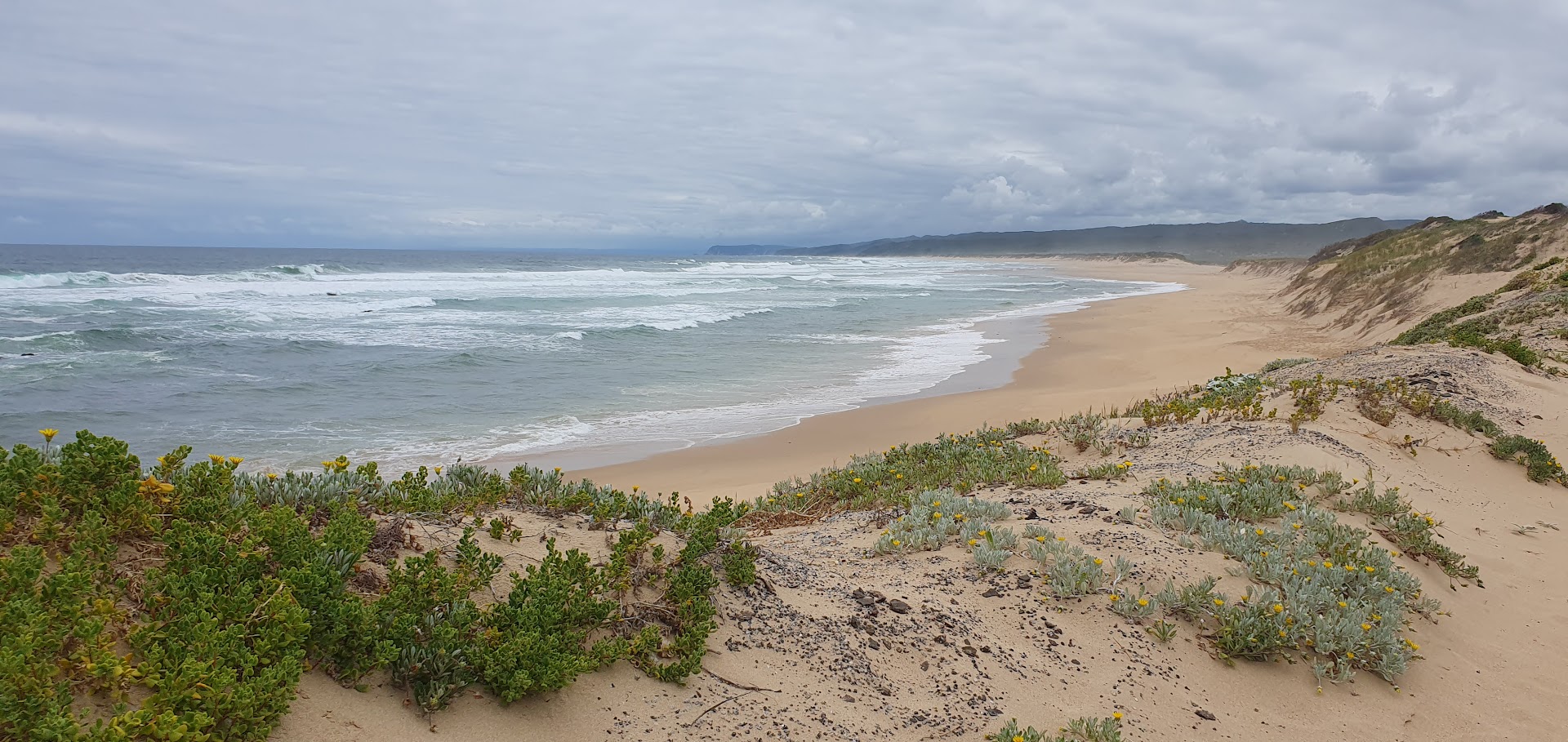
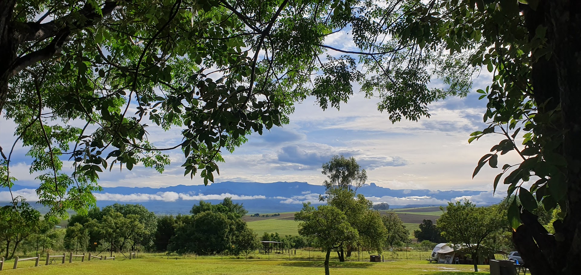
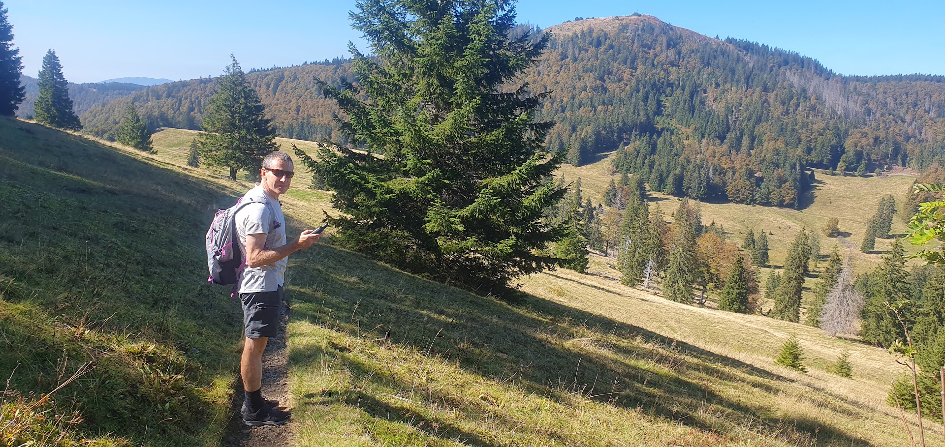
It was towards the end of my 3-week stay in Cape Town, long after our campervan adventure had concluded, that I returned to this coastline, visiting an old school friend Ralph and his wife Marion in Rooi Els. We visited the penguin colony at Betty’s Bay and spend some time at Kleinmond’s old harbour, where I was treated to a mid-afternoon fish lunch at KabelJoe’s seafood restaurant. Unfortunately, tge afternoon was marred by some idiots driving into the side of Marion’s little car. I stayed over and the next day Ralph and I tackled the Oudebosch hike in the Kogelberg Nature Reserve.
Located in the quaint coastal town of Betty’s Bay in the Overberg, the Stony Point Nature Reserve is home to a unique colony of African Penguins. Stony Point offers the public the chance to see these wonderful flightless birds up close, via the boardwalk through the colony, which allows the public to observe the penguins go about their daily activities in their natural habitat, without disturbing or disrupting them.
Also present in the colony are three species of cormorant; the Crowned cormorant, Cape cormorant and Bank cormorant, all of which breed on the outer rocks. There are also Hartlaub’s Gulls and Kelp Gulls which forage in the colony, while the Rock Hyrax, more commonly known as the Dassie, can be seen on the surrounding rocks.
The colony lies on the site of the old Waaygat Whaling Station, which was used to harvest and process whale meat in the early to mid 1900s. Remnants of the infrastructure for this long-defunct industry can still be found at the site.
Read the full blog and view photo albumand videoshere.
Read the full blog and view photo albumand videoshere.
Tuesday 19th December – Knysna to Mossel Bay, along the Garden Route of South Africa
Tuesday morning would see us leave on the next stage of our journey, after two days in Knysna. After a coffee with Dorelle at Ile de pain bakery and restaurant and a walkabout at the Marina at Thesen Island in Knysna, we drove to meet Ed and Elna just after the bridge over the Knysna River. Saying farewell to Dorelle, we continued west along the Garden Route through Sedgefield, Wilderness and George and on past Great Brak River to Mossel Bay.
The tidal estuary at the mouth of the Kaaimans River near Wilderness is crossed by a rail bridge, a distinctive landmark in the area. The Outeniqua Choo Tjoe, the last passenger steam train in Africa, crossed this bridge until the line was closed due to landslides in 2006.
Ed and Elna had arranged another private stopover at a friend recently widowed, whose late husband was known to them at Vaal Marina. Monika decided to move to the Cape and consequently had a house built at Hartland, a gated development near Hartenbos, Mossel Bay. Such housing developments, some located on golfing estates, have become commonplace in recent years due to rising crime in the country and the need for additional security.
* * *
We arrived in the late morn, given the relatively short distance which needed to be covered from Knysna. After decoupling the campervan from the Jimny and parking it on a grass patch next to the garage adjoining the house and connecting to a power point, we were offered a quick coffee by our host. The decision was made to not waste any valuable time, as we would be leaving for Hermanus the next morning. Ed and Elna were keen to show me the cave at Cape St Blaize, a natural grotto overlooking the sea, a vast cavernous space, 10m high and 72m wide, located directly below the lighthouse. Getting there involved having to drive through the centre of Mossel Bay.
Read the full blog and view photo albumand videoshere.
The first excavations at Cape St Blaize, in 1888, found artefacts going back 80,000 years. This would put occupation of the cave in the Middle Stone Age. However, more recent discoveries suggest that the cave was inhabited by the San (or Khoekhoek) people around 800,000 years ago. This would suggest that the Mossel Bay area was home to the very first people from whom we are all descended. There would have been an abundant source of food from the sea. Archaeologists have discovered that the first inhabitants had a diet rich in shellfish.
Although humans have long since left the cave it was later a haunt of bats, and it is sometimes known as Bat’s Cave. Today it is still inhabited – not by humans or bats but by inquisitive dassies (small furry relatives of the elephant).
The modern history of Mossel Bay began on 3 February 1488, when the Portuguese explorer Bartolomeu Dias landed with his men at a point close to the site of the modern-day Dias Museum Complex. Here they found a spring from which to replenish their water supplies. Dias had been appointed to search for a trading route to India by King John II of Portugal. Without realising it, actually rounded the Cape of Good Hope before landing at Mossel Bay.
By the time the Portuguese explorer Vasco da Gama reached the area in 1497, the Bay had been marked on the maps as Aguada de São Brás, (the Watering Place of St Blaize.
The PetroSA (Petroleum, Oil and Gas Corporation of South Africa Pty Limited) Refinery – which was commissioned as Mossgas in 1987 – is situated about 13 km to the west of the town’s central business district.[citation needed] This is one of the world’s largest Gas to liquids (GTL) refineries, and has always been a leader in the challenge of commercialising the GTL processes. It produces 36,000 barrels (5,700 m3) per day (bbl/d) – a crude oil equivalent of 45,000 bbl/d (7,200 m3/d) – using the Fischer–Tropsch process of converting natural gas (which is piped from offshore fields via PetroSA’s FA Platform).
After passing through the cave, I continued along a path that lead along the cliff face away from the lighthouse. Ed and Elna did not join me owing to Ed’s discomfort until he is able to undergo his hip operation. This led me to the start of the Mossel Bay Zipline, as clients were about to set off (see video). It is the longest over-ocean zipline in the world, at approximate 1100 meters long, at speeds of up to 80km/h, enabling one to enjoy unparalleled views of the cliffs, ocean and sea life.
I walked back to join Ed and Elna who were feeling peckish at this stage and suggested we try out the menu at The Spur, a South African restaurant that has been operating for decades as a franchise. We were pleasantly surprised that we were able to order a chicken schnitzel with mushroom sauce, a soft drink and dessert (pancakes or ice-cream and chocolate sauce in a glass) for just over R100!
On the way back, we decided to pop in to see my brother John’s wife Barbara at Hartenbos, a well-established holiday resort. She and her brother Horst were up for a few days from Cape Town at the invitation of Charmaine (my niece) and her husband and kids. They have long since been annual visitors but due to popular demand and the opportunity for generating revenue, the local school has made its sport fields available during the festive season, which is precisely where they were located. We enjoyed a few drinks with them.
The Afrikaans Language and Cultural Society (Afrikaans: Taal en Kultuurvereniging), also known as the ATKV, bought the farm Hartenbos, east of what was then the town of Mossel Bay, in 1936, and developed it as a holiday resort (now known as the ATKV Hartenbos Resort,[7] and considered the biggest self-catering resort in the Western Cape Province). This was a significant step in the development of the town’s tourism economy as it positioned Mossel Bay as a beach holiday destination – and beach tourism remains a major focus for incoming tourism in the 21st Century.
Monika very kindly allowed me to use the shower off the spare bedroom in her house. After dinner in the campervan, we joined her in her lounge after sunset for a few rounds of Rummy Cup, before retiring for the evening.
Read the full blog and view photo albumand videoshere.
Read the full blog and view photo albumand videoshere.
Sunday 17th December – Graaff Reinet to Knysna via George
We were up quite early at around 05h20, commencing preparations for the journey ahead. I showered quickly to freshen up, despite having done so the night before, using the outdoor shower cubicles. We were on the road at around 07h00. The route on the N9 took us through the towns of Aberdeen, Willowmore and Uniondale (the border between the Eastern and Western Cape lies between the latter two), passing over a number of mountain passes as we approached the coast, notably the flood defences catchment area at Windheuwelpoort.
The Outeniqua Pass, which lies in the Western Cape, carries the N9/N12 national road through the Outeniqua Mountains north of George. These mountains form part of the Cape Fold Mountains which connect George and the Garden Route coastal plain with Oudtshoorn and the Little Karoo.
Upon arrival at the coast, our route to Knysna took us via George, the Wilderness, Sedgefield and Knysna, all of which are along the so-called Garden Route of South Africa. The first glimpse of the sea and pristine, white sands is familiar and magical. On the eastern access road to George, we stopped to fill up with fuel and enjoyed an omelette, despite this being early afternoon.
Just then I texted my dear friend, Dorelle, who had offered to travel down from Port Elizabeth to meet us in Knysna, having booked a B&B near Leisure Isle, virtually around the corner from where we were staying privately for the next two nights. Elna’s daughter Liezl and husband Dono had rented accommodation adjoining a large house, from a Chinese businessman known as Johnny, prior to emigrating to Canada earlier in 2023. Ed and Elna arranged for the motorhome to be parked at the top of his driveway, since we only required a power point. Ed and Elna could happily shower in the motorhome, whilst I could do so at Dorelle’s, which she kindly suggested. As we were passing through George, Dorelle had reached Plettenberg Bay, on the way down from PE.
Parking the motorhome and settling in is not a 5-minute job, so Dorelle arrived whilst we were still in the process of doing so. Ed had got in touch days earlier with our cousin Tony Fryer, who has been living in Knysna for the past twenty years, for a late afternoon.meet-up and stroll around Leisure Isle, having driven up from Rheenendal, en route to Buffels Bay. I had last seen Tony many moons ago and he had really changed that much, despite being a similar age to Ed, who turned 80 in 2023. A keen cyclist, he looked well, trim and in shape, despite recent issues associated with a fall.
Elna, Dorelle and I extended our walk, with views of The Heads, a prominent Knysna landmark and we met up with Ed and Tony at a local coffee shop which was about to close for the day. As a qualified architect, Dorelle attention is always drawn to interesting architectural designs, exemplified by the many upmarket properties in the Leisure Isle area. The social problems associated with acute, widespread poverty are in evidence all over South Africa, with the Garden Route being no exception. Ecologically sensitive areas on the hilltops above Knysna where development has previously been resisted have given way to squatting and informal settlements.
I showered at Dorelle’s before we headed for the Waterfront for a dinner at a Portuguese restaurant. The hake and salad washed down with a fine chardonnay was delicious but I had to twist Dorelle’s arm into sharing an ice-cream with chocolate sauce. A lovely ending to a lovely day with a special friend!
Read the full blog and view photo albumand videoshere.
* * *
Monday 18th December– A day on the beach at Buffels Bay, Knysna
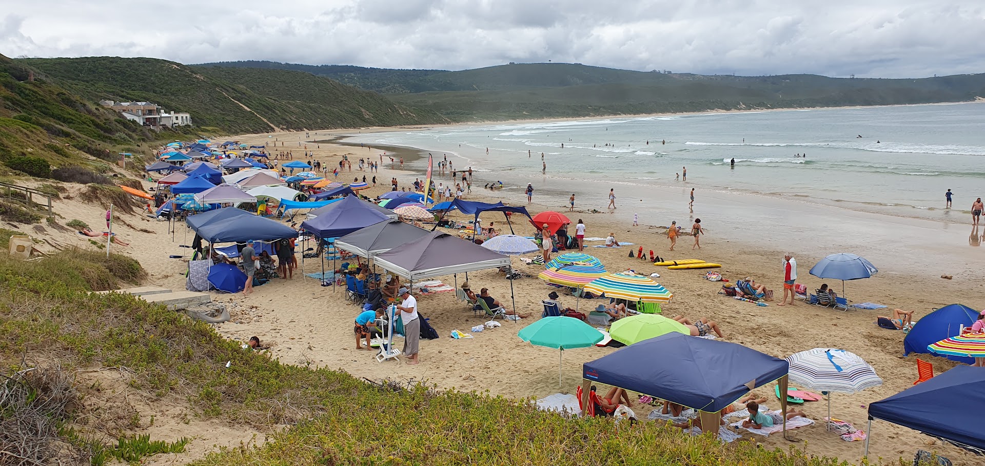
We had planned a braai (barbeque) for the next day however a late start at 08h30 meant that we were unable to grab a parking space near any one of the braai spots on offer. Instead, we opted for a swim at the main beach by carting only a beach umbrella and drinks cooler box from the car park. Our cousin did not join us, as we suspect he had an inkling that it would be overcrowded. As small as the world is, a woman under a large umbrella immediately adjacent to us recognised Elna, though related, they hadn’t seen one another in years – a discussion ensued in which they figured out the family connection.
Dorelle and I walked to get a coffee. We left, driving back to Johnny’s, where Ed and Elna decided it pragmatic to have a braai on the property. Back at her B&B, I showered and we decided to pass the rest of the day by driving to a lookout above The Heads, where the estuary of the Knysna River, which has its source in the Outeniqua Mountains, is located. Throughout our campervan tour, I had the thought of a scheduled meeting with the tenants of my house in Cape Town in the back of my mind. I discussed with Dorelle the possibility of a potential conflict arising, who patiently gave her perspective of the situation, for which I was later very grateful.
Read the full blog and view photo albumand videoshere.
* * *
Tuesday 19th December – Ile de pain restaurant, The Boatshed, Thesen Island, Knysna
Tuesday morning would see us leave on the next stage of our journey, after two days in Knysna. Dorelle fetched me around 08h30 and drove to the Marina at Thesen Island for coffee at Ile de pain bakery and restaurant, located at the Boatshed redevelopment, which she was particularly fond of from an architectural perspective.
Unfortunately, Ed and Elna had been too preoccupied with packing and other matters to join us (the logistics of a motorhome towing a Jimney around Thesen Island being problematic given the plethora of speedbumps), so we drove to meet them after crossing the bridge over the Knysna River. Here Dorelle bade us farewell before we continued west back towards George and she east in the direction of Plettenberg Bay. I felt quite sad as I had enjoyed her company very much, a view seconded by Ed and Elna.
Read the full blog and view photo albumand videoshere.
Read the full blog and view photo albumand videos here.
Friday 15th December
Bethlehem to Bloemfontein via Senekal and Winburg on toll road
To recap, on Thursday 14th December, before my brother Edward had dropped me off at Glen Reenen to do the Wodehouse Trail in Golden Gate Highlands National Park, we packed up immediately after breakfast and left Stop en Ry campsite just outside Clarens, after deciding to spend only one night there. Elna remained with the motorhome in Clarens. They spent the day in the picturesque little town until it was time for Ed to fetch me once I had completed my walk. We then hooked up the Jimney in Clarens and headed for Bethlehem.
Elna has a wide circle of friends and had arranged with a couple, known as Peet and Esme, who lived on a farm on the outskirts of the town, though they had established academy (private) schools, mostly with black students, which they had successfully run on business lines for a number of years. We struggled to establish the entrance to the farm, as the navigation app was unable to identify any known roads. To Ed’s annoyance, it took us in a wild goose chase along a gravel road, only to lead us all the way back to a tarred highway. A couple of phone calls later, we found the farm. The couple welcomed us with tea and rusks and Elna proceeded to reminisce with them about old times. We spent the night in the campervan whilst hooking up the motorhome to a power source in their garage. The couple very kindly invited me to shower indoors, which I managed to do before a thunderstorm rolled in overnight.
On Friday 15th December we hooked up the Jimny, bade Peet and Esme farewell and after putting in fuel at Ed’s preferred Sasol service station in town, headed out around 09h00 for Bloemfontein, encountering a thunderstorm and heavy rain with hail en route. Despite the stopover in Bethlehem which shortened the distance to Bloemfontein a tad, Ed still had about 250 km to cover. The Reyneke Park campsite just outside the city proved a comfortable location, boasting a separate toilet, shower and washroom facility per individual booking. Elna made a delicious curry and rice dish for dinner. It stormed overnight and I was forced to make a mad dash for the ablution block to avoid getting soaked.
* * *
Upon arrival a cat and its kitten local to the Reyneke Park campsite had put in an appearance at our motorhome. On Saturday 16th December, as we prepared to leave around 07h30, the kitten showed up. Elna put out some milk which the poor animal happily lapped up. The journey from Bloemfontein to Graaff Reinet would prove the longest stretch in the motorhome of our tour to Cape Town, totalling roughly 430 km. It’s a parched, dry landscape of scrubland but not uninteresting.
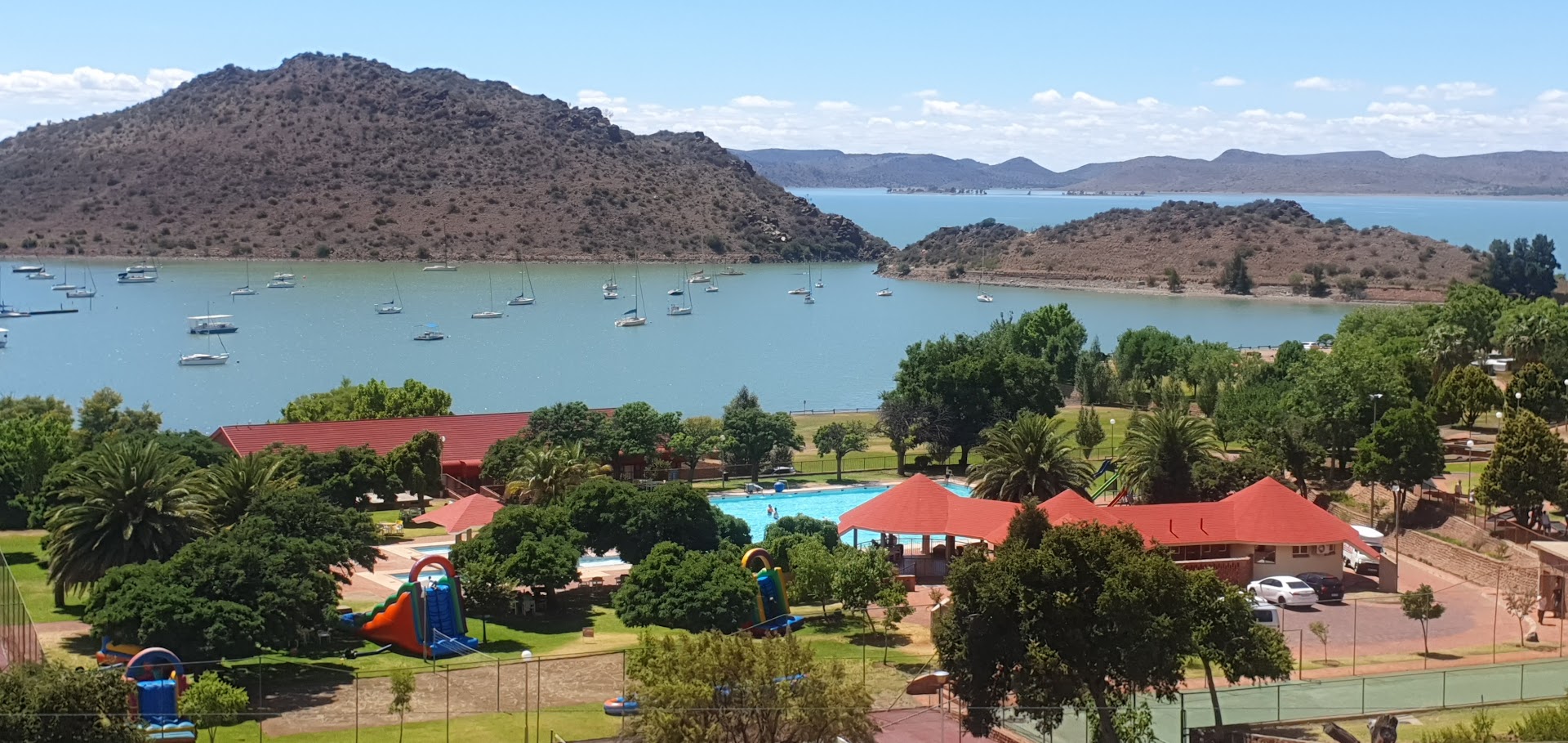
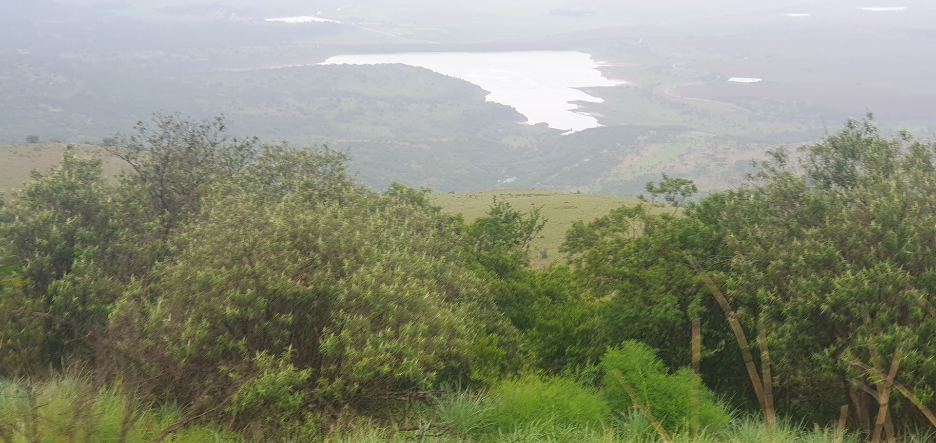
We stopped at Gariep Dam on the Orange River, located on the border between the Free State and Eastern Cape provinces. It is the largest dam in South Africa. The word gariep in local languages means “river” or “big water.”
I was dropped off at one end of the dam wall and walked across to the other end where they had waited for me. While Ed filled up with fuel for the motorhome once more in Colesberg, I dashed off to the local supermarket in search of something to snack on. The Magnum ice-creams for all went down a treat. Ed and Elna usually ensure that a cooler box is stocked with drinks, kit-kat chocolates and nuts and raisins on a daily basis. A huge flask is filled with hot water for tea and coffee for when they choose to stop on the roadside. The long journey can prove tiring and Ed has over time, in travelling in the campervan, made use of a wet cloth soaked in water to cool his brow, which helps him to stay awake.
Read the full blog and view photo albumand videos here.
* * *
Nieu-Bethesda (Afrikaans for New Bethesda) is a village in the Eastern Cape at the foot of the Sneeuberge, approximately 50 km north of Graaff Reinet. It was founded in 1875 as a church town, like many other Kario villages, and attained municipal status in 1886. The name is of biblical origin and means “place of flowing water”.
In the 1930s, a Nieu Bethesda-born teacher known as Helen Martins returned to the town. After her father’s death in 1945, Martins began transforming her home into a work of art. She employed Koos Malgas, a Nieu Bethesda local to assist her with her artwork. She and Malgas constructed cement and glass statues inspired by biblical texts, the poetry of Omar Khayyam, and the works by William Blake. In 1976, Martins aged seventy-eight, took her own life by swallowing caustic soda. Martin’s house known as The Owl House is now run by the Owl House Foundation formed in 1996 and is now a major tourist attraction. It was also the subject of a major film.
The Sneeuberg mountain range was historically known as “Sneeuwbergen”, meaning ‘snow mountains’ in Cape Dutch and refers to a significant portion of Southern Africa’s Great Escarpment in the Cradock, Murraysburg, Richmond, Graaff Reinet, Nieu-Bethesda and Middelburg districts of the Great Karoo, most of which are in the Eastern Cape Province. The mountains of the Great Escarpment are geologically distinct from the Cape Fold Mountains, which extend east as far as Port Elizabeth.
* * *
We arrived in the picturesque, historic town around mid-afternoon, locating the Profcon Resort along Somerset Street. The site occupies an entire block, entrances squeezed between quaint residential properties. One would never have imagined that a site accommodating motorhomes and the like was located there, a virtual oasis. It’s a gorgeous, classy establishment. Ed unhooked the Jimny after we set up camp. We waited until it had cooled before he drove me into town, whereafter I walked the streets to explore Graaff Reinet’s historic architecture. Ed made a fire and that evening we had our first braai (barbeque) of the trip.
Graaff-Reinet was established by the Dutch East India Company in 1786, after Cape Town in 1652, Stellenbosch in 1679, Paarl in 1687 and Swellendam in 1745. The town is named after then-governor of the Cape Colony, Cornelis van de Graaff and his wife. The town was originally established as a trading post to expand trading inland from the Cape Colony.
Read the full blog and view photo albumand videos here.
Read the full blog and view photo albumand videos here.
Thursday 14th December
Hiking the Wodehouse Trail in Golden Gate Highlands National Park
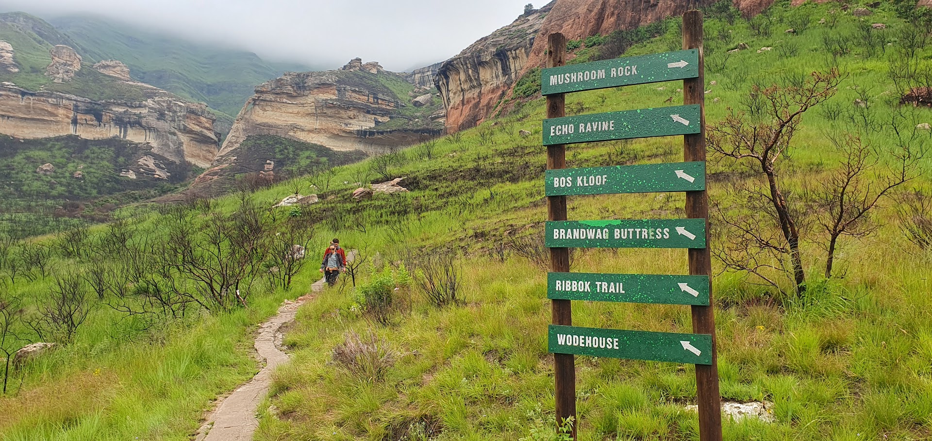
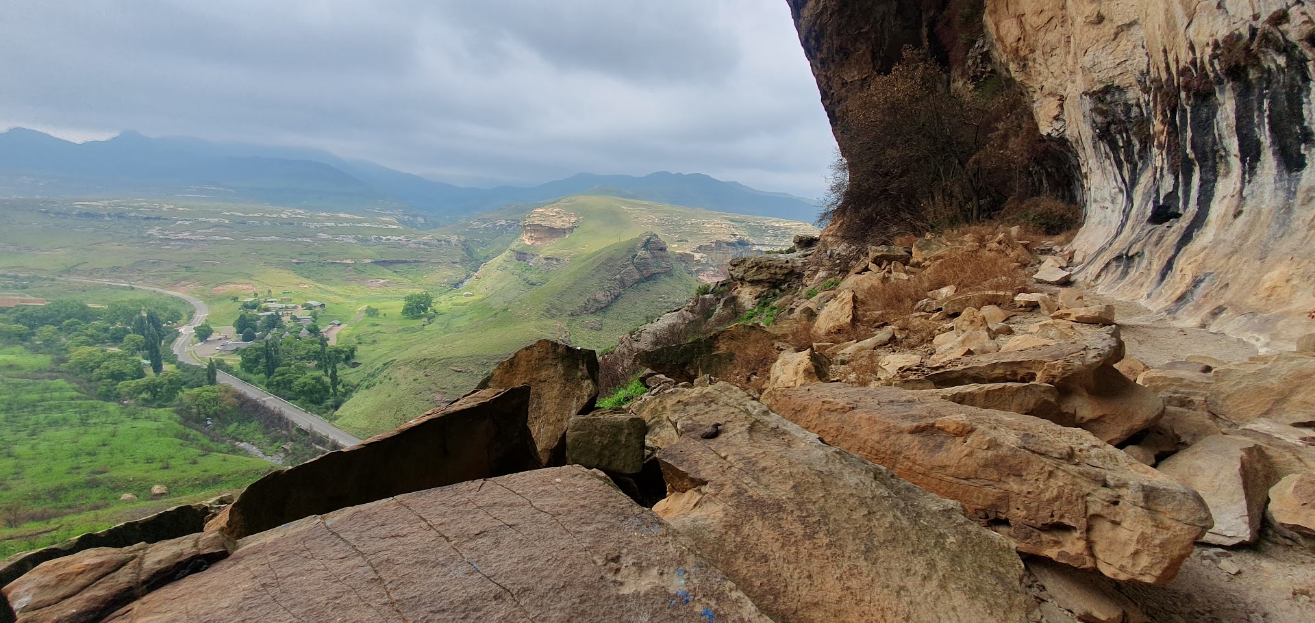
After breakfast at Stop en Ry campsite just outside Clarens, my brother Edward drove me the 20-odd km along the R712 back to Glen Reenen Rest Camp around 08h30, for my intended hike in the Golden Gate Highlands National Park. Permit purchased and instructions received, I was told that nobody else had as yet booked for any hikes, which only served to add to a sense of trepidation and foreboding. It was overcast and though the forecast did not allow for potential thunderstorms until the early afternoon, what if I got lost? Reviews I had glanced the night before had only added to my anxiety, one describing having experienced a hike of the Wodehouse Trail as a “Near Life and Death experience”, owing to the onset of a thunderstorm en route. The thought had crossed my mind as to whether the walk should undertaken clockwise or anticlockwise – the desk advised the former.
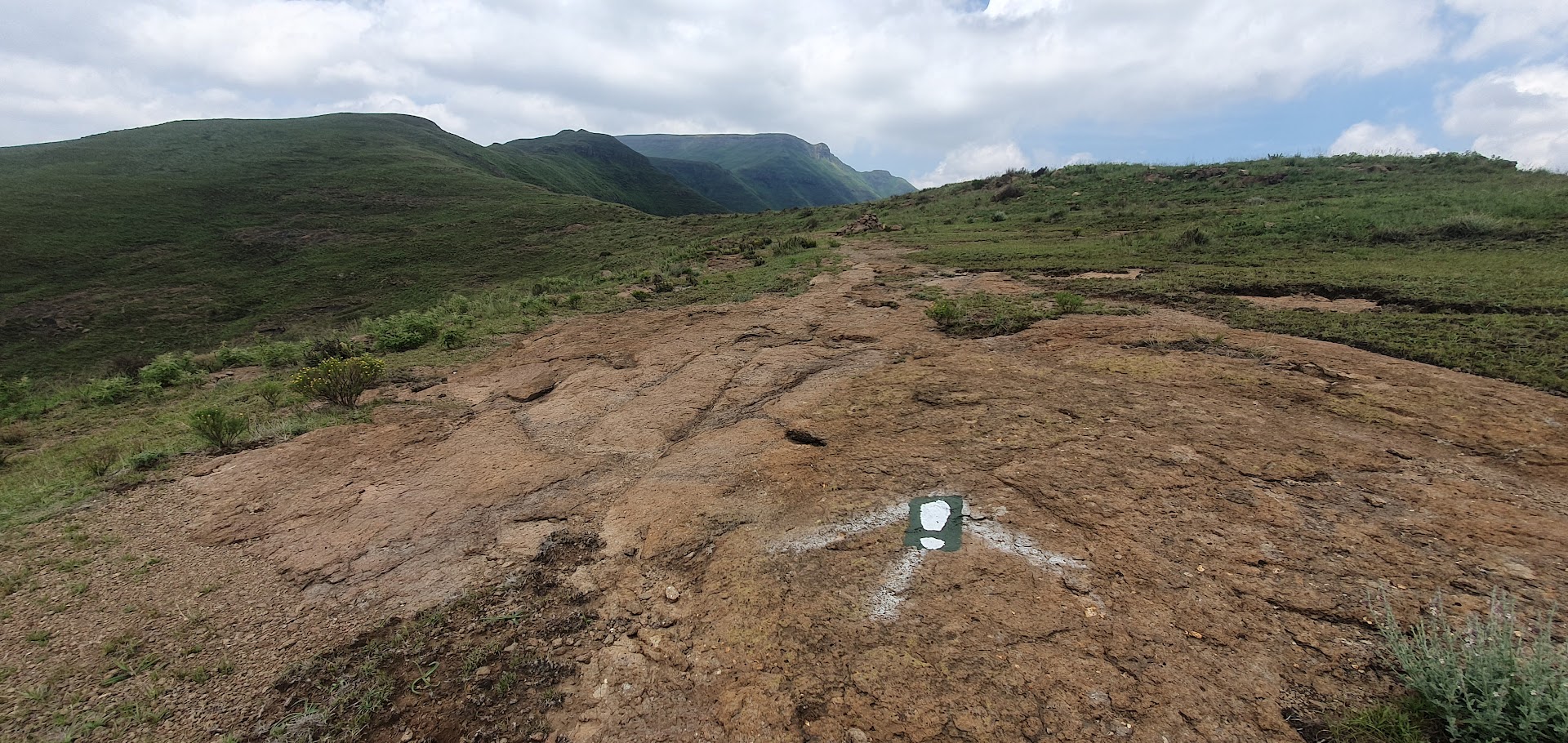
Crossing the R712 from Glen Reenen Rest Camp, all trail routes are clearly signposted at this early stage. Crossing a stream, the path to Mushroom Rock continues up to the left. It was apparent that an extensive fire had occurred at some stage in the past. Soon one reaches a rocky overhang. Continuing on, a set of chains serve to hoist one up to Brandwag Buttress. Whilst views of Glen Reenen Rest Camp disappear from view, Brandwag Hotel on the R712 towards Clarens emerges from below.
Turning towards the peaks above, the path continues a short distance. At this point one reaches the top of a man-made stairway descending in the direction of the R712, which seemed totally counter-intuitive. I was in doubt as to whether I was on the correct path however signs at the base of the stairway confirmed the direction of the Wodehouse and Ribbok Trails.
Read the full blog and view photo albumand videos here.
Slowly I began a gradual ascent along the valley with the R712 down below to the left, passing the Brandwag Hotel in the process until it eventually began to recede in the distance behind me. The narrow path, overgrown in sections, steepens before levelling out, until one reaches the junction of the Ribbok and Wodehouse Trails, the latter requiring a sharp turn to the right. Here I stopped for my first break and enjoyed some tea from the flask. All self- doubt had all but dissipated. I was feeling strong and enjoying the walk at this stage.
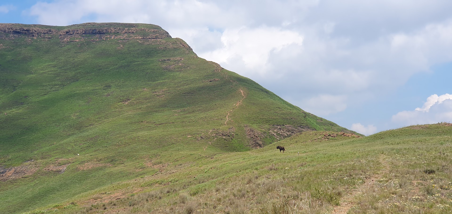
Painted footprints marked the direction of the trail to Wodehouse Peak. In addition, numbers appeared at strategic intervals, all the way to the top. Wildlife began to appear, with greater numbers further down in the valley, including Gemsbok and Wildebeest. As the incline steepened, I encountered a lone Wildbeest directly ahead of me. Grazing before noticing me, it turned in my direction, then moved forward a few paces. All of a sudden it jumped in the air, landing on its forelegs, snorting in apparent sign of irritation, repeating the action several times, before bolting down the hillside. Miraculously, the clouds had long since lifted and sunshine bathed the landscape.
Read the full blog and view photo albumand videos here.
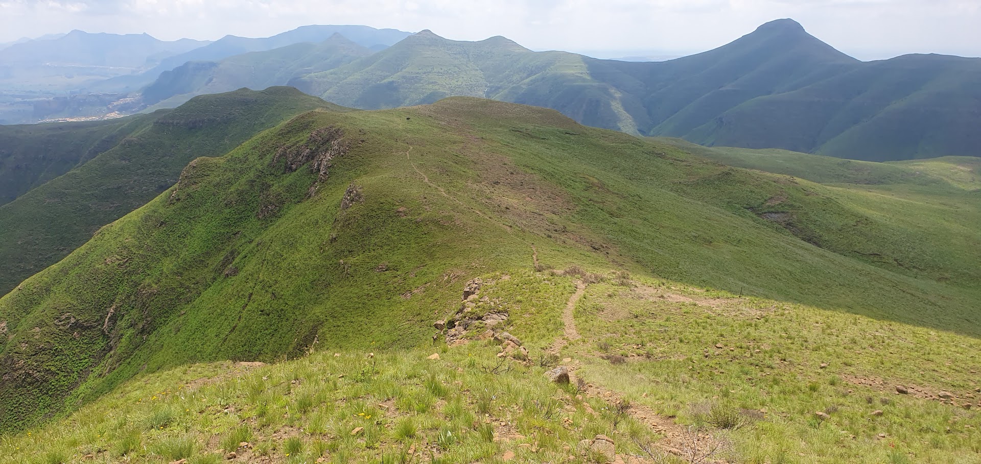
By the time I reached what I assumed to be Wodehouse Peak, I was exhausted. Deemed a 3-hour walk, I realised that I was never going to complete the Wodehouse Trail in that time. I had allocated an additional hour but even that wouldn’t be enough. I dud not want my brother to drive all the way from Clarens, only to have to wait an eternity before I showed up. I whatsapped him once and then a second time later. The problem for me was that the route off the mountain wasn’t clearly marked. I guessed that I probably needed to descend down a steep gorge at Wodehouse Peak but had read of it being quite intimidating. Furthermore, the painted footprints and numbers continued along the ridge and down the more gentle slopes that led away off the summit. The views were quite incredible through 360 degrees. I had never even dreamt of such beauty in this part of the world and the effort and self-belief had been totally worthwhile. I hadn’t met a human soul on the entire walk.
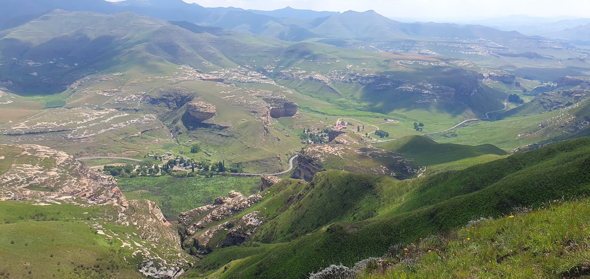
After descending multiple slopes I reached a rocky plateau not far above the R712 on the Drakensberg side of Glen Reenen but struggled to find a pathway that led off it, until I discovered some faded white footprints to the left. I followed this path off the plateau that dropped down until I reached a stream. Noticing that the path seemed to ascend once more towards one of the tall sandstone buttresses and that I would somehow find my way around it, to where I had initially started my walk that morning, I instead opted to head towards the R721, which didn’t seem to be all that far away. I couldn’t find a way through however due to another concealed drop in the landscape, so I returned to the stream, finding a different path that eventually led to the road. I called Edward who had arrived at Glen Reenen a few minutes earlier, asking him to drive a kilometre up the road to pick me up.
I had even asked to report back to the desk to confirm that I had completed the walk successfully and safely. It had taken me six and a half hours to complete. In fairness, I had stopped often to take photos and the confusion at the end on the descent had only added to the time. I mentioned this to the park officials at the desk. The path I had descended was an old discontinued path but after enquiring as to why the numbers continued, they indicated that they would look into it. Its rare that I drink coca-cola however it was deserved on this occasion, to quench an almighty thirst. Back at the campsite just outside Clarens, after a shower I felt human again. It had been a splendid day out that had enriched the soul.
Read the full blog and view photo albumand videos here.
Read the full blog and view photo albumand videos here.
My annual holiday to South Africa produced an unexpected twist during the planning stage, when my eldest brother and his wife, based at Harbour Town, Vaal Marina, asked if I would consider a stopover. I agreed on one condition, that they take me to the Drakensberg, the highest mountain range in South Africa, on the border with the landlocked Lesotho. Their lifestyle changed when they acquired a campervan to undertake regular trips around South Africa.
Rather than fly to Cape Town, it was suggested that we drive down in the campervan. Over a matter of weeks, an itinerary took shape, incorporating three days in the Drakensberg and two at Golden Gate National Park (near Clarens), where I hoped to do some walks, before driving via Bloemfontein and Graaff Reinet to Knysna, located on the Garden Route in the Eastern Cape. The final leg along the coast to the Mother City would incorporate stops in Mossel Bay and Hermanus, a total journey lasting two weeks.
* * *
Thursday 7th December
My summer adventure back home to South Africa suffered setbacks and challenges at the very outset. As a result of train strikes in the United Kingdom that had persisted all week, I erred on the side of caution to ensure that I made it to the airport well ahead of my flight departure. Even the Elizabeth tube line had suffered breakdowns. To cut a long story short, further chaos resulted in my being stuck in Frankfurt overnight on Thursday 7th December, caused by the collapse of Lufthansa’s computer system earlier in the day, compounded by bad weather and other factors, which had led to the airline unable to process any flight information. This resulted in my missing my Lufthansa connecting flights to Johannesburg. Other long-haul flights were also impacted and thousands of people rebooked or wait-listed on later flights. I spoke to people who missed connecting flights to Hong Kong and Argentina, as well as shorter flight destinations in Europe.
Read the full blog and view photo albumand videos here.
* * *
Friday 8th December
Fortunately, I was able to secure hotel and taxi vouchers to enable me to get a good night’s sleep, take a shower and enjoy a good breakfast. I managed to get into the Lufthansa Service Centre just after 08h00 on the Friday morning. Having been automatically wait-listed on a Lufthansa flight direct to CT for that evening, given the circumstances which held the airline responsible, it didn’t take much effort to persuade the agents to rebook me on a Condor flight to Johannesburg, scheduled to leave Frankfurt airport at 20h00.
* * *
Saturday 9th December
We arrived at Oliver Tambo Airport in Johannesburg after 9 a.m. but despite the delay, my brother Edward and his wife Elna were still trilled to see me. It had been some years that I last found myself on the Highveld, which in summer is renowned for the most spectacular thunderstorms. On the way to Harbour Town, Vaal Marina, we paused for brunch at Die Stasie, a quaint, unassuming local coffee shop and breakfast venue. The evening at Harbour Town was spent unpacking and unwinding.
* * *
Sunday 10th December
After extensive preparation and packing of the campervan, we left Harbour Town at 08h00 on the Sunday, as planned. Edward acknowledged that my arriving on the Saturday only proved beneficial in allowing them more time. The route took us along the N3 south to Harrismith in the Free State province. Here we filled up both the Pacer campervan (Mercedes 5-cylinder diesel engine) and the Suzuki Jimny with fuel, the latter in tow.
It rained extensively en route. After passing Sterkfontein Dam along the R74, we negotiated the extraordinarily beautiful Oliviershoek mountain pass passing Little Switzerland, a family-oriented resort, with views across the valley below, still shrouded in mist. Here the landscape is adorned with acacia trees. The mountain pass signals the border between the Free State and Kwazulu-Natal. We reached ATKV Drakensville holiday resort around 14h00, locating our stand and settling in.
Read the full blog and view photo albumand videos here.
* * *
Monday 11th December
With two full days at Drakensville, I had considered a number of hiking possibilities, which included the Tugela Gorge and Postman’s Helmet Trails in the Royal Natal National Park, offering views of the famous Drakensberg Amphitheatre, as well as the Rainbow Gorge Trail near the Cathedral Peak Hotel. Unfortunately, heavy rain fell all day on the Monday, resulting in this day being lost to the elements. We took a drive to the Park’s entrance, just to get out. Late afternoon the weather began to clear and hopes were high for the next day.
* * *
Tuesday 12th December
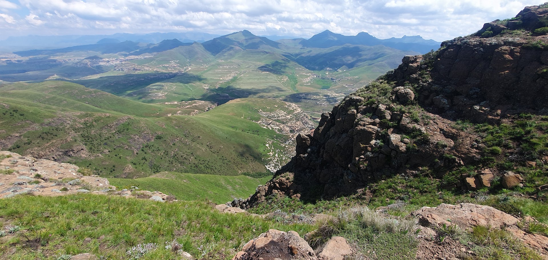
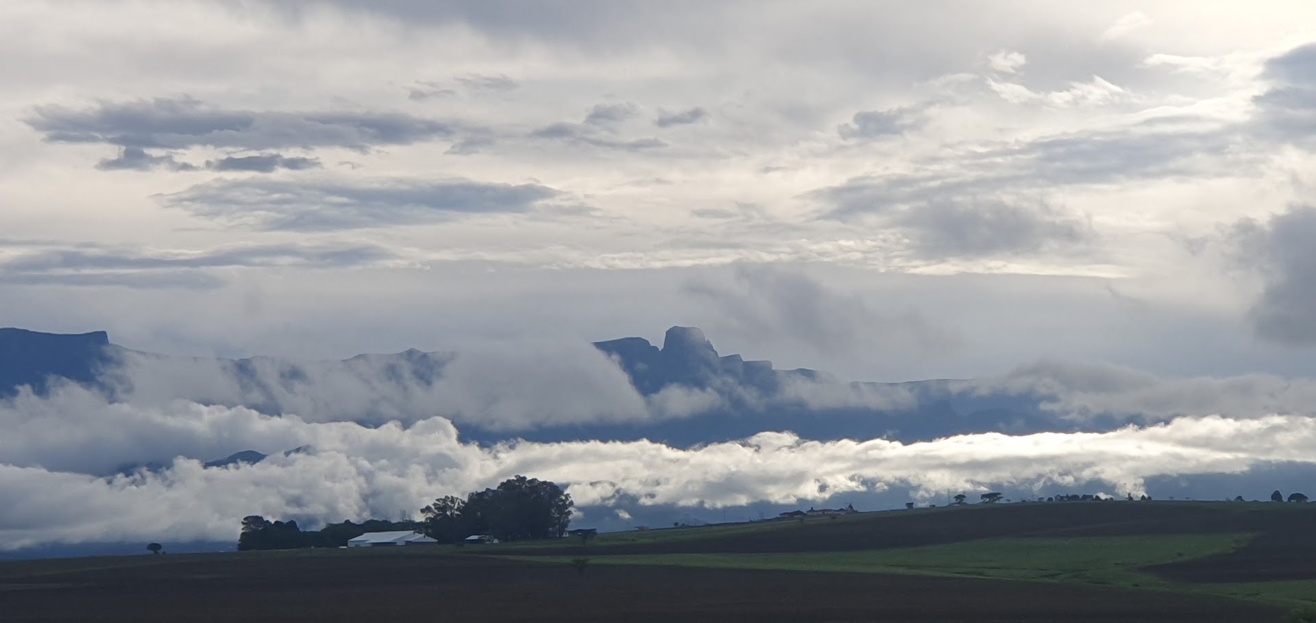
Finally blessed with a day of sunshine, in hiking terms, this was not to be passed up on. We could not have wished for clearer blues skies and a more perfect view of the Drakensberg Amphitheatre. We drove to the Royal Natal National Park shortly after 08h00. Having driven there the day before (where I had shot myself in the foot by saying I was visiting from the UK), the parks official at the gate had doubted me not only on the validity of my South African citizenship but also my predictions regarding the weather. The registration process when undertaking a walk calls for a required amount of information in the interests of safety, such as colour of rucksack, details of next of kin etc.
It is interesting to note the relief of the interior of South Africa in relation to the coast, specifically in terms of the route we would find ourselves travelling now and over the coming week. The map of South Africa shows the central plateau edged by the Great Escarpment and its relationship to the Cape Fold Mountains in the south. The portion of the Great Escarpment shown in red is officially known as the Drakensberg, although most South Africans think of the Drakensberg as only that portion of the escarpment that forms the border between KwaZulu-Natal and Lesotho. Here the escarpment rises to its greatest height of more than 3,000 metres.
Read the full blog and view photo albumand videos here.
Hiking the Tugela Gorge Trail
My brother Edward and his wife Elna dropped me off at the Gorge car park (first left after crossing the bridge just after the Visitor’s Centre). Their plan involved a less strenuous walk at The Cascades.
I had been thinking that I should do the Policeman’s Helmet Trail to higher ground, but the heat determined a more pragmatic decision, that the longer but lower Tugela Gorge Trail might be a better option, which takes one through sections of forest. A young Dutch couple started off at the same time. Prior to my arrival from the UK my local Royston weekend walks had tailed off a bit for various reasons, so I was not in the best condition fitness-wise. Nevertheless, I paced myself and arrived at the river gorge around 12h30 (roughly 3 hours). It is a good track that rises gradually from beginning to end, excepting for the final undulating passage through the forest, down to the river. I was amazed at the variety of trees, including yellowwood and protea. Birdlife was in abundance. In the forest, crickets and presumably cicadas created a cacophony of noise.
I relaxed as the water rushed by. I had decided on a cautious approach and not venture further up the Gorge for a possible view of the Tugela Falls, which would have involved some boulder hopping The return being virtually all downhill, I managed to shave half an hour off the outgoing time, arriving back around 15h30, half an hour earlier than our scheduled rendezvous time. I settled down on some grass waiting to be picked up by Ed and Elna in the Jimny.
* * *
On the way back to Drakensville, we stopped off at the Tower of Pizza, a restaurant of note in the area, where Ed and Elna had enjoyed lunch earlier in the day. A quaint farm setting located near the township on the way back to Drakensville, the establishment also offers accommodation. The black manager, Pah, served uo a delicious pizza and came over to share a joke, his sense of humour coming to the fore. I had mistakenly assumed he was also the owner but he just smiled and said “I wish”. After a shower, we soon hit the sack for the night.
Read the full blog and view photo albumand videos here.
* * *
Wednesday 13th December
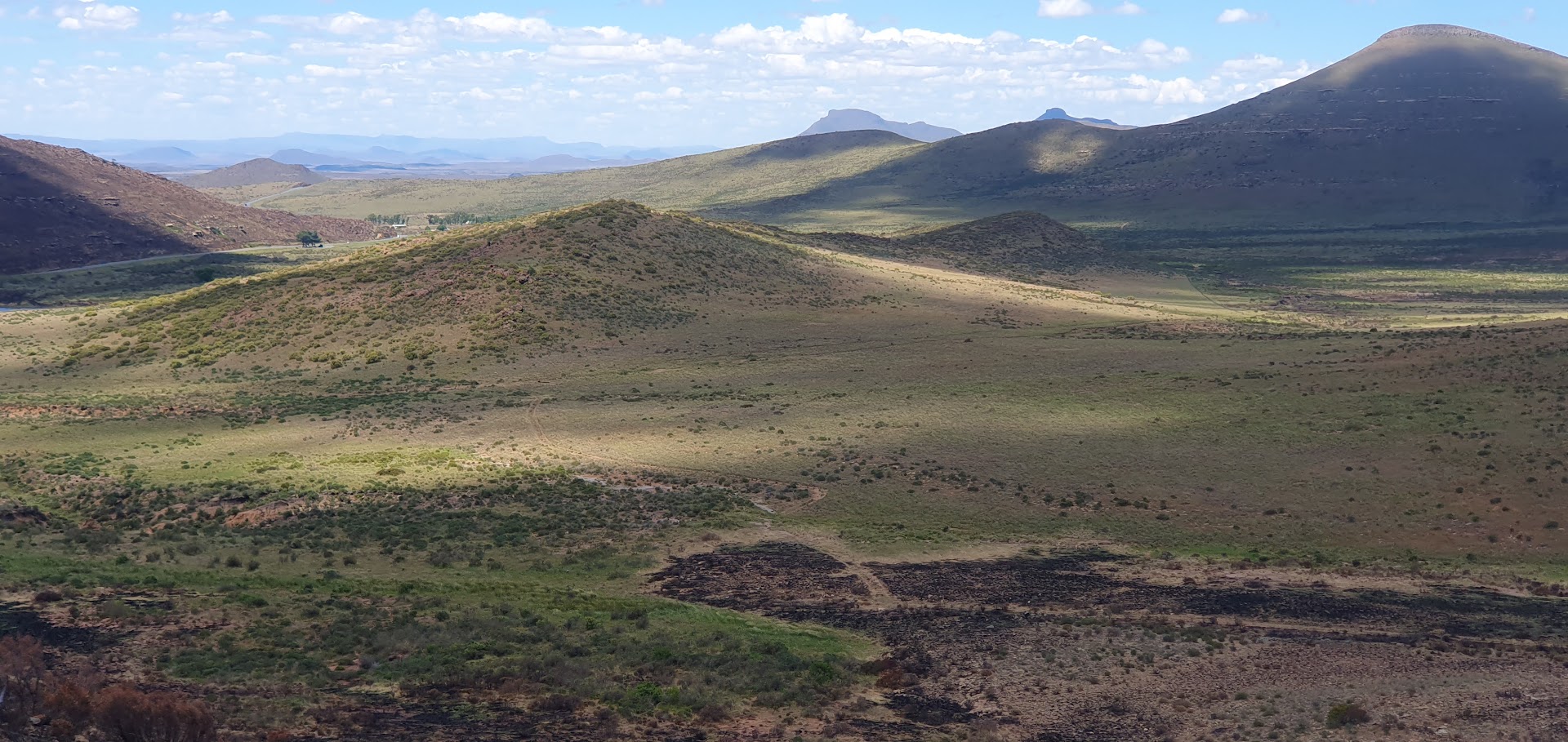
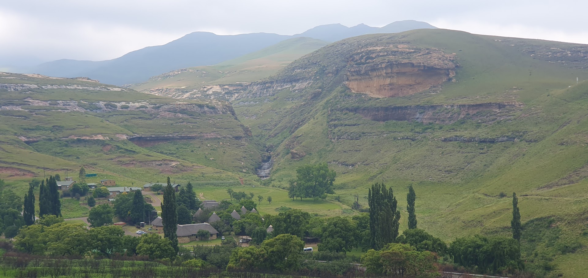
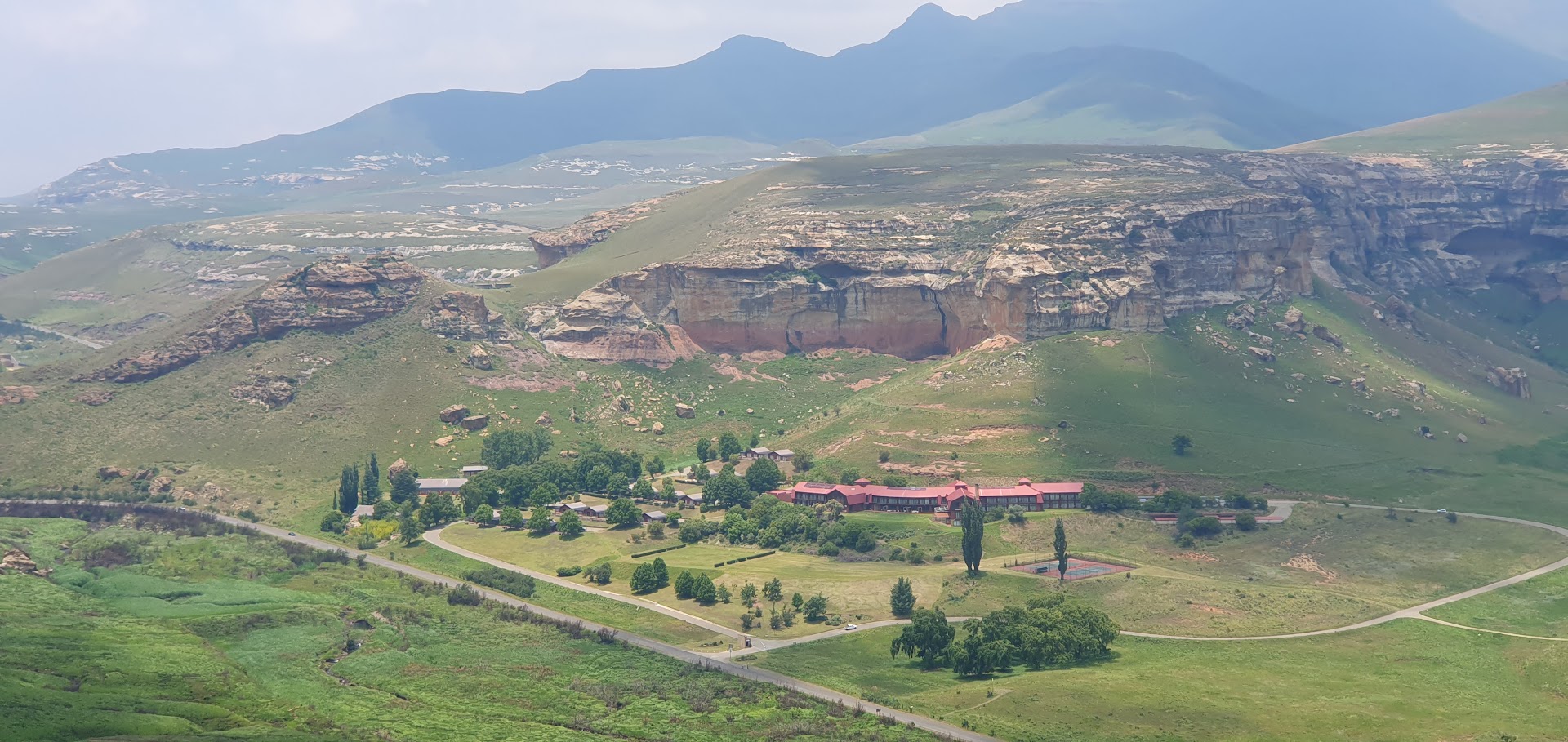
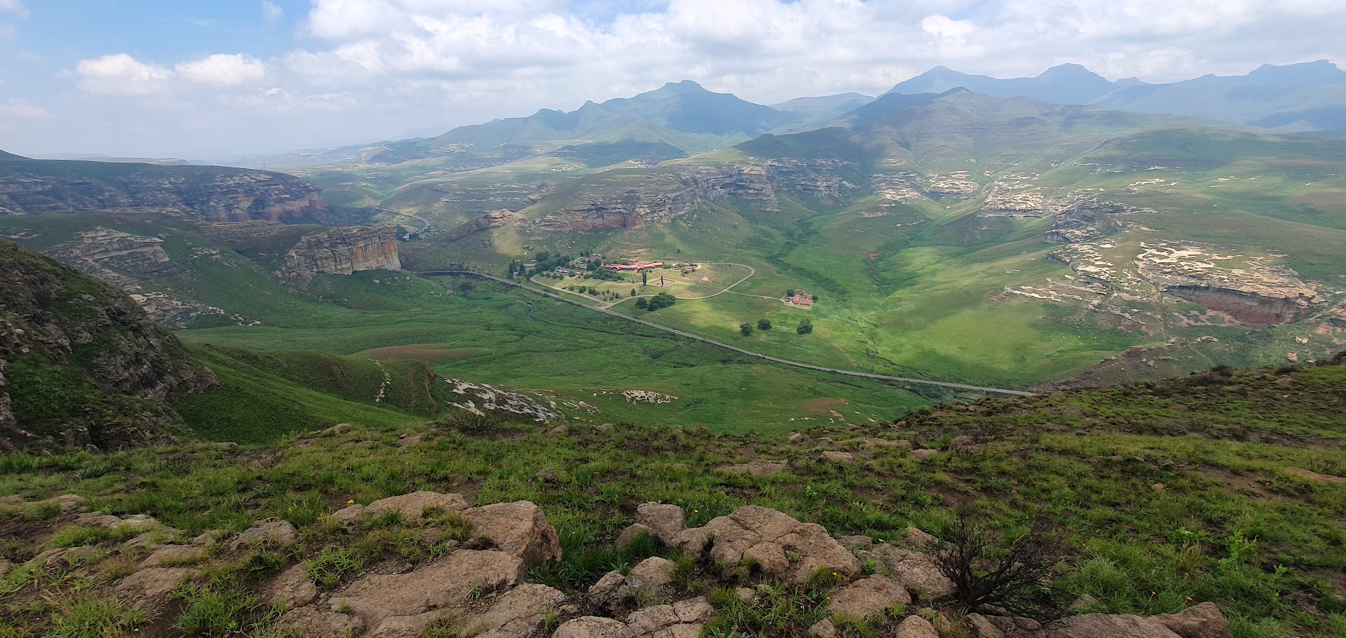
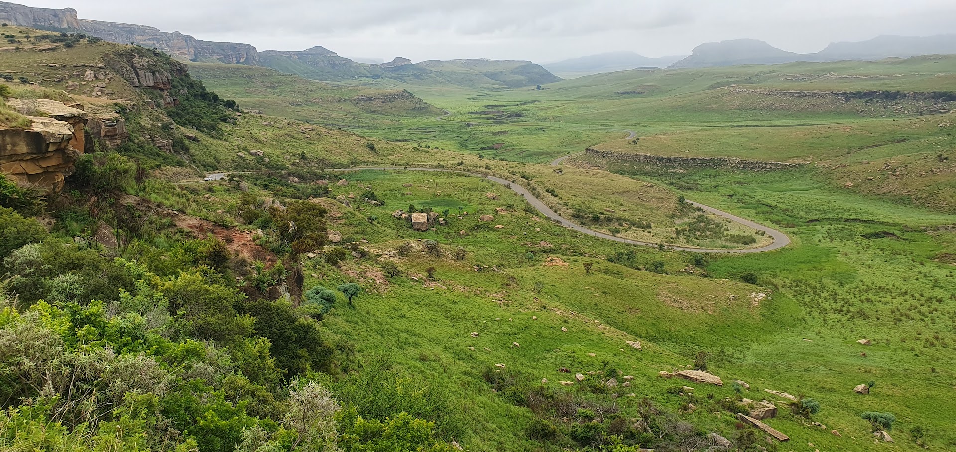
We packed up at ATKV Drakensville, heading out on the road around 09h00, once again negotiating the Oliviershoek mountain pass as well as passing the Sterkfontein Dam on the R74 in thick mist. Turning onto the R271 would lead us directly towards the Golden Gate Highlands National Park, close to the Lesotho border. The huge somewhat imposing orange-tinged eroded sandstone cliff face at its eastern entrance appears dramatically. Another feature of the area is the numerous caves and shelters displaying San rock paintings.
We continued through the park, which covers an area of 340 square kilometres, first over a pass before descending to the Glen Reenen Rest Camp located roughly at the halfway point, enclosed by mountains. Here we stopped around midday, to enquire about the walks, which start from the campsite on the opposite side of the road. The daily entrance charge for a South African is R67. The original plan was to overnight near Clarens for two nights, so given that it was relatively late in the day, I decided to delay and risk attempting the walk only the next day, hoping that the weather would hold out.
As luck would have it, the sun came out as we reached the charming, rather quaint, somewhat bohemian little Free State town, which turned out to be quite different to what I would ever have imagined it to be. Walking the streets around its main square, we explored one of a number of art shops before deciding on a restaurant for a lunch.
The location of our stopover for the night turned out to be a bit off the beaten track. Located on a cattle farm south of Clarens on the Ficksburg road, Stop en Bly is definitely overpriced for what it offers. The sloping terrain made it difficult to locate a flat spot for the motorhome. The campsite is lined on one side by a row of bluegum trees. Though the site boasts magnificent views of the Lesotho mountains, it’s a bit exposed and lacking in character. The Caledon river separates the two countries.
The owner, Bees van Blerk, came over to assist in picking a spot and providing the rundown. The ablution block and showers were neat and tidy. I was shocked to learn that, in this day and age, he shies away from ethnic diversity in terms of the clients he is willing to accept. His cattle farm deploys technllogy to provide the security to protect his livestock from theft from across the border in Lesotho.
We settled down as dusk approached, but stormy clouds on the horizon suggested a thunderstorm was imminent. It never truly materialised. My brother’s access to DSTV meant that I could watch my beloved Borussia Dortmund in a Champions League football match that ensured they finished top of their group. Elna tried cooking fish and vegetables in their new acquisition, a steam fryer however the results were not quite what they had hoped for, so a bit more practice is required.
Read the full blog and view photo albumand videos here.
Read the full blog and view photo albumand videos here.
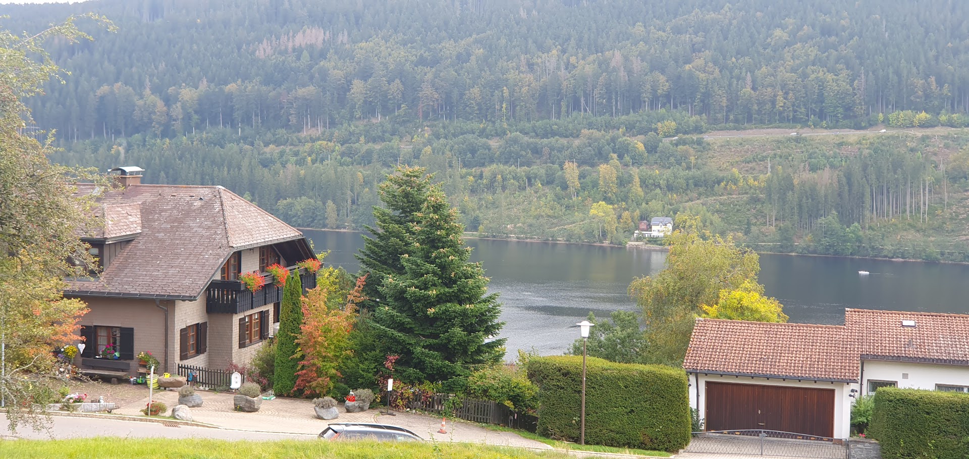
Saturday 30th September – Lake Titisee Walk & Freiburg City Visit
Sunday 1st OctoberAfter an absence of a few years, I decided to pay a visit to my friend Zoltan in Switzerland, having flown from Luton Airport on Easyjet Friday late afternoon. I have to say that negotiating Luton Airport security turned out to be a far more pleasant experience generally-speaking than at Stansted, which handles a greater volume of passengers. The head steward on Easyjet ensured that we were provide with a quirky yet camp brand of highly entertaining in-flight entertainment, testing whether passengers were actually listening to announcements by nonchalantly throwing in Geneva as the flight destination.
Zoltan stays in a neat, cosy apartment in the Oerlikon district of Zurich within easy reach of Zurich airport. He boasts about having female company around the place who does almost everything for him. I’m still trying to get my head around the concept of Alexa.
After a quick breakfast, in the mid morning we drove from Zurich, completing this 14km walk located just across the border, around Lake Titisee in the Black Forest, with 329m total elevation. It was an exhilarating start to the more strenuous walk planned for the next day. In downtown Freiburg, we walked around town before stopping off for Flammkuchen, essentially a thin-based pizza, together with Zoltan’s friend “Z” (she prefers not to have her full name mentioned on social media), who had travelled down by train from Waldorf for the day. The weather was warm and the town buzzing, as demonstrated by the clip showing an impromptu dance group entertaining the crowds.
Read the full blog and view photo albumand videos here.
* * *
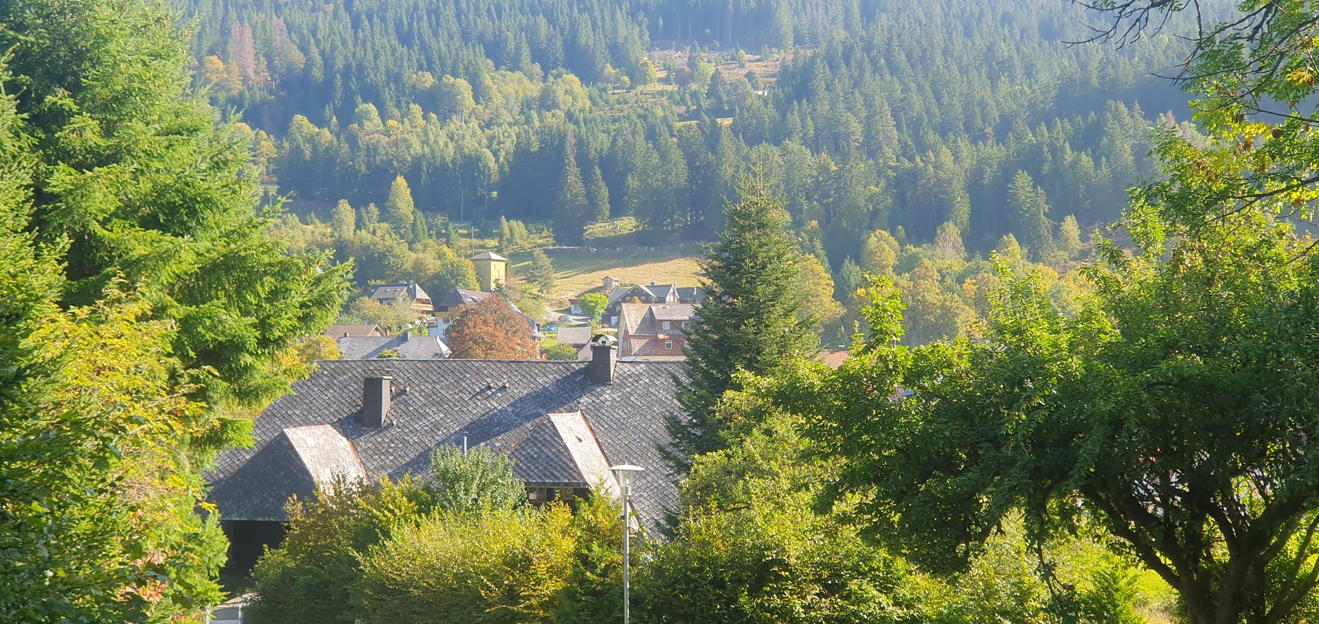
Sunday 1st October – Menzenschwand Black Forest Walk
Zoltan had decided to really put me through my paces Sunday, with a 20km-odd Black Forest walk setting out from the hamlet of Menzenschwand and heading into the hills which circumnavigate the valley below, with a total elevation of between 700 and 800 metres. The route is known as St Blasien, which takes its name from the town of the same name that boasts a beautiful basilica, which I had visited before and which we had to pass through en route to Menzenschwand . Before starting the climb, we had to pass through to the outskirts of this typical southern German farm village, characterized by large double or triple storey farmhouses with sloping roofs and balconies decorated by flowers in the summer. It seems that the town was gearing up for Oktoberfest. Climbing was relentless but mostly within the forest, which provided much-needed shade, shielding us from the morning sun. We reached a lookout hut that gave us a glimpse of the valley below.
From here we dropped down to open countryside where cows grazed unperturbed, reaching Krunkelbachhütte, a solitary guesthouse situated just above a saddle in the upper valley, where we stopped for drinks. The place was humming, serving traditional Bavarian pub food to the multitude of hillside walkers turning up with regular monotony. Just beyond the saddle, our route continued as we ascended through a section of forest once more, taking a short cut along a path where a skier had lost her life during a mid-winter avalanche. We reached the hillside above the ski resort of Hebelhof, with Feldberg, the highest point in the Black Forest, clearly visible over to the west. We stopped at a Hütte for coffee and water. It was from here that, after reaching Caritas-Haus, an interdisciplinary therapy centre, that we followed a dirt track meandering through the forest on the northern side of the valley, where we found ourselves being passed regularly en-route by groups of mountain bikers, a number of which were in fact e-bikes. We began our descent along a steep track following a stream, which led us back down into Menzenschwand. Exhausted and sweat-drenched but well satisfied by the gruelling hike, we headed back to Zurich after changing into drier attire.
Read the full blog and view photo albumand videos here.
* * *
Monday 2nd October – A day exploring downtown Zurich & A visit to Konstanz Thermal baths
After two days of walks, the latter of which at Menzenschwand proving pretty strenuous, I was looking forward to a somewhat more relaxing day, so after a slow start to the day, I opted to explore downtown Zurich, requiring only a half-hour trip on the S-10 tram from Oerlikon. Zoltan was back at work. The magnificent Landesmuseum just across from the main railway station documents the story of Switzerland from the banks of Bahnhofstrasse to alpine farms and mountains, from Heidi and Helvetii to cheese and cantons. It was quite warm so I stayed in the shade and walked along Limmatquai to Bürkliplatz, named after Arnold Bürkli (1833–1894), the engineer responsible for the construction of the city’s quays.
It was here on the lake front where Quaibrücke is located and where the outfall of Lake Zurich into the Limmat river commences, that I first photographed a beautiful sculpture by Hermann Hubacher, when passing through Zurich after spending 3 months working as a student in Germany in 1979-1980. Adorning the line of trees along the quayside, the statue depicts the abduction to Olympus by Zeus, in the form of an eagle, and his beautiful lover Ganymede. I reached the opera house via Utoquai, before returning along the back streets via Oberdorfstrasse to the Grossmünster, a Romanesque-style Protestant church who’s twin towers remains a city landmark. I stopped for a much-needed break for coffee & cake at a cafe at Rathausbrücke. Finally, I walked along Niederdorfstrasse to Central, where I took the S10 tram back in the late afternoon.
* * *
Though I had been introduced to saunas some years ago, it was after a colleague and I met up with fellow engineer Zoltan that my love and appreciation of saunas moved up a new level. I have visited a number of baths in Hungary and in particular in the capital. After all, wellness and spa culture have been a part of the Hungarian lifestyle for hundreds of years. Hungary’s spa culture began in Roman times, but some of Budapest’s most stunning bathhouses were built during the 150 years of Ottoman rule. These 16th-century bathhouses have similar structures with central octagon-shaped pools topped by high domed ceilings through which rays of light pierce the water. Besides the Turkish bathhouses, Budapest boasts many other historic baths, earning it the moniker “Spa City.”
With Tuesday being a public holiday in Germany, Monday evening looked like a good bet, when the facility would be less crowded. It’s an incredibly relaxing experience. I particularly enjoy it when on the hour every hour, a member of staff enters the sauna room and ladles of water (usually scented) are thrown on the sauna stones – this immediately evaporates and increases the humidity in the air in the sauna. He then uses a towel to agitate the air in all directions – this procedure lasts several minutes and is invariably executed with great humour. It is much appreciated by all and usually results in a round of applause at the end.
Read the full blog and view photo albumand videos here.
* * *
Tuesday 3rd October – Höhenweg Amden hike
Zoltan had suggested this rather intriguing mountain walk, which involved some travelling from Zurich. Taking the S2 train from Zurich Oerlikon which follows the southern shoreline of Lake Zurich directly to the line’s final destination, Ziegelbrücke-Süd, the 650 bus then heads via Weesen on Walensee through a number of farm villages, including Amden, up into the mountains to the final bus stop at Arvenbüel. The overall round trip is a bit on the pricey side, costing CHF 55.60 and that did not include the cost of the Mattstock chair lift down to Amden, at the end. Many do the walk in the opposite direction, by taking the chair lift first.
From the bus stop the walk commences a up a steep rise past some houses, reaching woodland. The route is well marked and one need only follow the Ammler Höhenweg trail signs. After passing through and crossing some grassland, a gravel road reaches a tarred road that then winds its way up the valley for a couple of kilometres, eventually reaching a farm. Here a gravel road leads off to the left before one takes a pathway which climbs steadily along the outer edge of the hillside. After reaching the top, a short diversion via a less obvious route over grassland takes one to a peak called Gulmen.
Returning to the original track, red and white markings painted on stones indicate the way off the hillside, the rutted path zig-zagging and dropping steeply down the slope before easing off as one enters a forest. The path follows the contours of the hill slopes, passing a Hüte, where I was tempted to stop for a pint, as I had been consuming water at a steady rate. I ventured on before eventually joining a gravel road for a long exposed stretch that passes beneath the peaks of Hinter Höhi. Signposts appear which may only serve to confuse anyone unfamiliar with the area, as there are numerous alternative walking possibilities and one might think that the correct path might not seem intuitively correct. By following the signs to Niederschlagwald however, which has a little picture of a chair lift, I ended up at the right place in the end.
The last stretch of the walk to the Hüte (a stop-off for food and drink) comes into view at the top of a long winding tarred road. I had met an American woman en route who has been living In Switzerland for 40 years and still plays the cello and teaches music. We stopped for a quick drink at the Hüte . The Amden-Mattstock Sesselbahn (chair lift) is another 10 minutes further on, which takes one down to the village of Amden. Costing CHF 10 for a 15-20 minute ride, it’s a bit like floating and a rather pleasant experience. The views are breathtaking and the clanging of cowbells from the livestock creating a real cacophony. We reached the lower station and managed to pay the fare just in time to catch the bus at Amden, which is on the same route. Though the total distance walked is only 8.4 km and estimated to last about 3 hours it seemed longer. I was wrecked afterwards, mainly because it was quite hot. I waited for the 16h19 S2 train back to Zurich.
Read the full blog and view photo albumand videos here.
Read the full blog and view photo albumand videos here.
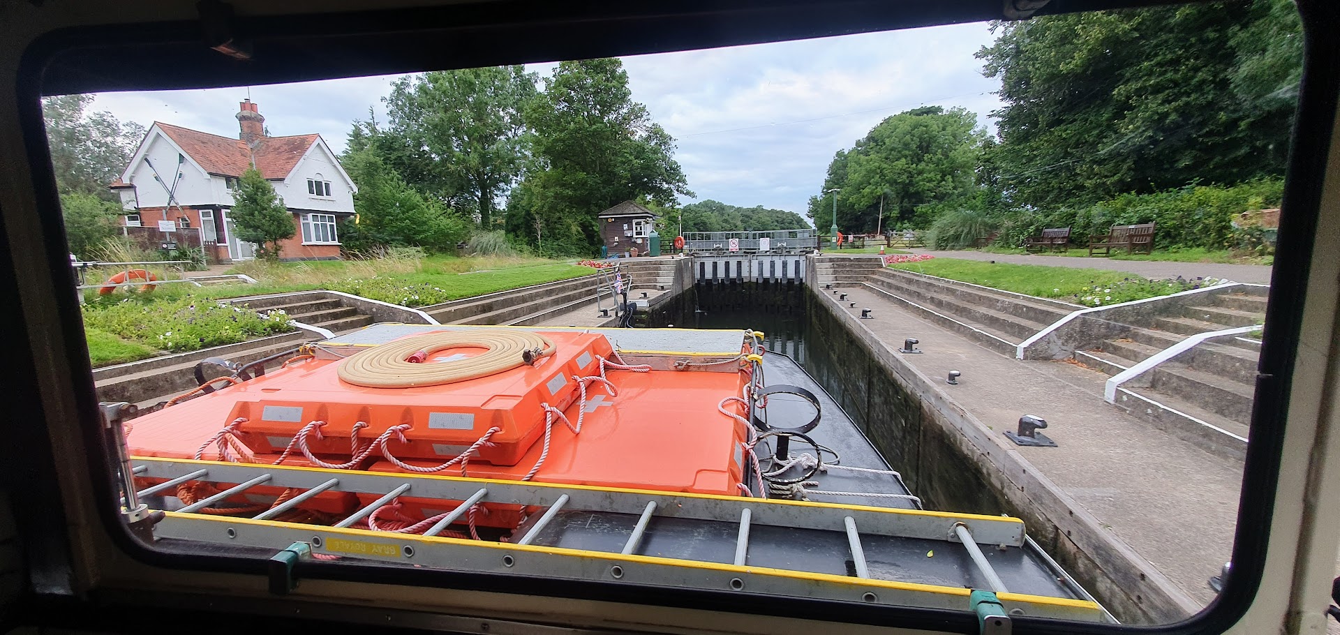
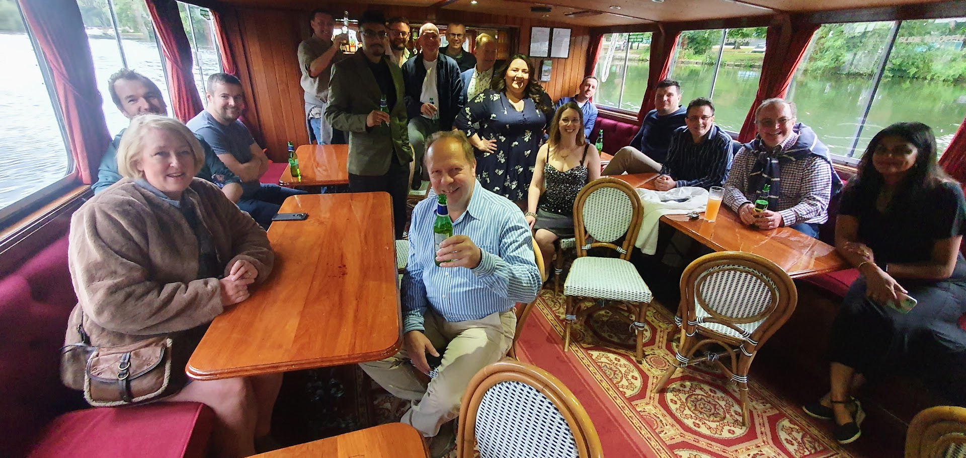
Another year on at Miura Systems in High Wycombe and the second of the annual company summer outings since my arrival came to pass. Sharon always seems to come up with the goods and this event was certainly no exception. The previous year we had been treated to a day out at Windsor racecourse. On this occasion however we were heading for the water. Picked up by a hired bus at the office, we were transported to the quayside in Windsor in close proximity to Windsor Castle, where we boarded the cruise vessel operated by Frenchbrothers. The group totalled roughly 20-odd, after some had withdrawn from the event at the last minute. The route upstream would see us navigate Boveney and Bray Locks to Maidenhead, taking in a magnificent sunset along the tranquil waters of the Thames, before returning along the same route, a round-trip of roughly four hours.
An onboard disco hammered out a mixture of 80’s and more recent dance music, whilst food in the form of spicy chicken burgers and salad fed the hungry, washed down with drinks from the bar. Countless riverside properties boasting the sort of opulence that would make your eyes water, came into view. Most of us on board would settle for the garden gazebo or boathouse. All tried their hand at placing their bets at roulette which had been laid out on a table at the head of the vessel. This largely made up the evening’s entertainment. The well-dressed croupier put in a significant shift as chips purchased with fake money were placed by the expectant, eager participants. We reached the quayside at Windsor some time after eleven. The bus arrived shortly after that to transport us back to the office and downtown Travelodge, where some of us had been booked in. A small group led by the in-form John Barton had concluded that the night was still young and decided to head for the Windsor clubs for a bit of a razzle. A thoroughly enjoyable experience laid on by Miura had been well appreciated by all.
Read the full blog and view photo albumand videos here.