Just over a year of working in Ireland, it was time once more to explore another facet of this beautiful and enchanting country. Having hired a car which I picked up at Hertz, Shannon Airport, early Friday night, I simultaneously secured a booking at a B&B in the little village of Doolin on the Atlantic coast, a noted centre of traditional Irish music, for the following evening. Intel colleague Fiona and her friend Lorraine had expressed interest in joining me for Saturday’s planned walk on a section of the Burren, located in north-west County Clare, about an hour’s drive from Shannon. Sunday’s itinerary remained flexible but would most certainly include the stunning and dramatic Cliffs of Moher. Whereas the Burren seems exposed and desolate, the Cliffs of Moher appear dark and mysterious. Little wonder that they featured in Harry Potter and the Half-Blood Prince.
Despite having been given directions to her house, we instead met on the on the outskirts of Ennis, before heading north-west along what could arguably be described as the scenic route, along off the highway, narrow single lane bi-directional roads bordered by hedgerows, with more twists and turns than a Stephen King novel, passing through the towns of Corrofin and Lisdoonvarna. We found parking at an abandoned house next to the Caher River near St Patrick’s Church, in the Caher Valley. The weather couldn’t have been better. Crossing Fanore Bridge and walking a few hundred yards up the road to Murrough, we picked up the pathway which formed part of a walk known as the Black Head Loop, running parallel to and above the R477 to Ballyvaughan, with the higher ground of the Burren to our right.
Continuing around Black Head along the northern shore, we missed the connecting path that veered off to the right (as indicated by a sign), instead dropping down to a farm near the road.
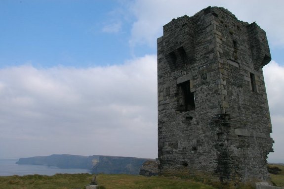
A couple of hundred yards further on near a sixteenth-century tower house that stands guard over the northern shoreline of the Burren, we were able to make our way up to the route that zig-zagged from there towards a saddle located between Gleninagh Mountain and Cappanawalla, stopping at a wall of loosely piled stones, enjoying a cup of tea as well as enabling us to catch our breath. Instead of continuing to follow the Black Head Loop, we headed up towards the 317 metre mountain peak, across alternating landscape of grass and limestone rock, all the more interesting with each and every step taken.
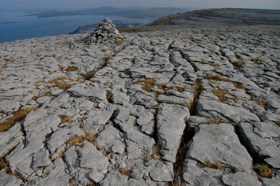
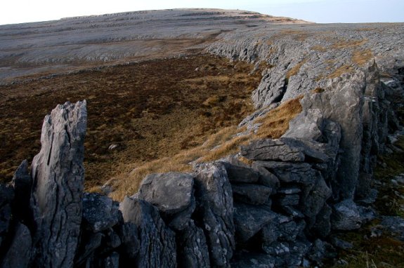
From here we could see across the Atlantic towards Connemara and Galway Bay. Retracing our route to this point from where we had rested at the saddle, Ballyvaughan lay just beyond, to the east. For a moment I was lost in the sheer breathtaking beauty before me, though my thoughts drifted as they often do in settings such as this, causing me to spare a thought on the anniversary of my late mother’s passing away. Ahead of us to the west, the landscape dipped before rising again in the distance towards the next set of cairns, at 314 metres. A long, pile of stones assembled to form a wall ran in the same direction. But it was what lay beneath my feet that was also of photographic interest. Fissures in the rock slabs, like some sort of paving project gone horribly wrong, created a unique visual experience. Around May, I’m told, flowers begin to bloom in the gaps between the rock, transforming the landscape in the process.
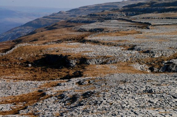
Fiona was keen to press on due to a later engagement, so reluctantly, I had to curtail my activities with the camera somewhat. What was initially considered a 3 and a half hour walk was turning into something much longer, not that I was complaining, mind. The Burren, meaning “great rock”, is one of the largest karst landscape regions in Europe, measuring approximately 250 square kilometres. It is a geological formation shaped by the dissolution of a layer or layers of soluble bedrock, the rolling hills of which are composed of limestone pavements with criss-crossing cracks known as “grikes”, leaving isolated rocks called “clints”.

A lunch stop at the next cairn, just before the next highest point on the Burren, close to Black Head.
As we progressed, the drop in the relief at certain points, though not significant, was such that the way down to the next level proved nigh on impossible, given that there isn’t an obvious path. Turning around and looking back, the rock seemed to resemble a large, even wave of flowing lava moving towards us that had cooled instantly and been frozen in time, except that this landscape was not of volcanic origin. Near another set of cairns just shy of the peak, the girls stopped for lunch. I soon caught up with them. After resuming the walk and crossing over the peak proper, we descended to the ringfort at Black Head. Radiocarbon determinations from these excavations are remarkably consistent, indicating that the main period of ringfort construction and use was from AD c.500 to c.1000, although this particular ringfort may have been constructed later. In Irish language sources, they are known by a number of names, including cathair (anglicized caher or cahir). Here we encountered a bunch of giggling gerties led by their guide. Seasoned archaeologists? I think not.
The final descent down to Black Head Loop proved tricky, clumps of grass often hiding cavities underneath or covering solid rock. We reached our cars six and a half hours after our departure that morning. It had been a grand stroll indeed. I drove to Doolin and the Activity Lodge B&B, where I had booked to stay for the night. Doolin is one of three places (Galway and the village of Rosseveal on the north-west shore of Galway Bay are the others) with ferry services to the Aran Islands. The neat and spacious room on the first landing, with its wooden floor and sky windows, proved more than comfortable. Ravenous with hunger and given a map of the layout of pubs in the town by the host, I opted for a short stroll down to Gus O’Connors Pub along Fisher Street for a bite, around 18h30. The place boasts a link with tradition, judging by the framed poster on the wall of a 1968 Rory Galagher concert at a County Clare music festival. The town is a noted centre for traditional Irish music, which I’d hoped to sample later around 21h00. I briskly returned to the relative comfort of my room where I remained, owed partly due to the throbbing pain from the torn cartilage in my left knee, coupled with fatigue from the day’s activity. Sadly, I missed the music too.
* * *
After an 8 a.m. Irish breakfast dished up by the very friendly hostess, I decided, upon her recommendation, to walk to the Cliffs of Moher along a path still undergoing reconstruction, rather than drive there. It’s a distance of some 5 km along what is referred to on the maps as the Burren Way, yet it felt longer, due to the route climbing steadily in altitude.
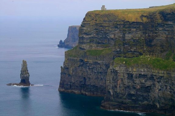
The skies were overcast however it remained dry. The Cliffs of Moher are located at the south-western edge of the Burren. They rise 120 metres above the Atlantic Ocean at Hag’s Head, and reach their maximum height of 214 metres just north of O’Brien’s Tower, 8 km to the north. Receiving almost one million visitors a year, the cliffs take their name from an old fort called Moher that once stood on Hag’s Head, the southernmost point of the cliffs. Geologically, they consist mainly of beds of Namurian shale and sandstone, with the oldest rocks being found at the bottom of the cliffs. There are an estimated 30,000 birds living on the cliffs, representing more than 20 species. These include Atlantic Puffins, which live in large colonies at isolated parts of the cliffs and on the small Goat Island. Also present are hawks, gulls, guillemots, shags, ravens and chough. I must have seen hundreds if not thousands of birds nesting on the cliff face, as I looked down where the sheer vertical cliff wall was visible.
Fiona had mentioned that she be out kayaking with friends off the Cliffs of Moher the next day [see their photos], which turned out not to be the case, though as I passed by O’Brien’s Tower, a round stone tower near the midpoint of the cliffs built in 1835 by Sir Cornelius O’Brien, an Irish politician, to impress female visitors, I did spot three bright red sea kayaks down below on the relatively placid waters and wondered whether she was among them. Dying for a cup of tea by the time I had reached the tower, where I encountered busloads of tourists, I opted to press on further south. The area near the tower is the focal point of the Cliffs of Moher as far as visitor’s are concerned, much of it up to the viewpoints on the edge of the cliffs being paved with large slabs of stone.

With Hag’s Head still some way off, I spotted Fiona’s friends (in the three red kayaks at the bottom of the photo).
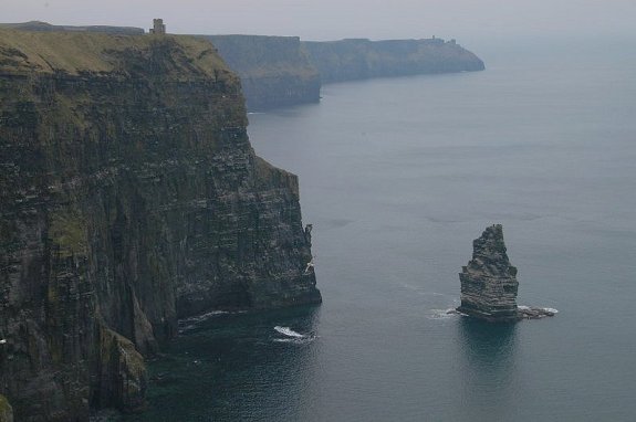
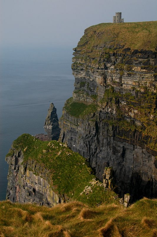
Just below O’Brien’s Tower, a stack known as Braunaunmore, a mere sniff at 67 metres, has been climbed. They say that the best approach is near the left-hand side of the seaward face. So too has the buttress below the tower, known as O’Brien’s Direct, at 321 metres. Start 30 metres left of the crest of the buttress at a crack, is the recommendation by those who have gone before. I have subsequently learnt that climbing records for this area generally date back to 1990. There were a number of local climbing groups who used to tackle some of the climbs at the Cliffs of Moher on an annual basis however, following a tragedy in April 2000 when two climbers were killed
by falling rocks, there has been very little rock climbing activity at the Cliffs of Moher since then. I have it on good authority that the only groups who have climbed the higher sections of the cliffs in recent times are the local coastguard volunteers who have conducted training exercises and also were involved in the recovery of a body in 2009.
The Visitor’s Centre, built into the hillside approaching the cliffs and covered in grass [see images], is also intended to be environmentally sensitive in its use of renewable energy systems including geothermal heating and cooling, solar panels, and grey water recycling. From the cliffs and from atop the watchtower, on a clear day, visitors can see the Aran Islands in Galway Bay, the Maumturks and Twelve Pins mountain ranges to the north in County Galway, and Loop Head to the south.
Today was not a clear day.
The sun threatened to burst through the clouds, lighting the golden swathes of grass fluttering in the breeze along the cliff edge. Fierce winds are known to pound the Atlantic coast of Ireland, so much so that controversial plans to build wind farms have been proposed by the British government, which would certainly blight this beautiful landscape. I reached Hag’s Head and turned back, after eating the last of a bunch of grapes I hoped would quench my thirst. It was warm despite the breeze. Rays of sunlight beamed down in the distance over Liscannor.
By the time I had returned to the Visitor’s Centre, Id had my fill and did not relish trudging all the way back to Doolin. Fortunately, the staff at the information desk proved very obliging and offered to call for a cab. A half an hour and a cappucino later at the appropriately named Puffin’s Nest Restaurent, Tony arrived in his 7-seater vehicle. An amicable fellow, we chatted on the drive to the B&B. Upon learning that I was South African, the conversation quickly turned to Oscar Pistorius, hero of the London 2012 Paralympics, who had made headlines recently for the wrong reasons.

The beauty belies the potential drop. At Hag’s Head they reach 120 metres, though the highest point, just north of O’Brien’s Tower, is 214 metres.

A close-up of Braunaunmore and O’Brien’s Tower. The buttress below the tower, known as O’Brien’s Direct, at 321 metres, has been climbed.
It was three in the afternoon. Galway had been a considered option however the walk put paid to that. I decided to head down the coastline via Spanish Point to Kilrush, before cutting back to Ennis and finally Shannon, arriving back at the apartment around six. Spanish Point was named after the unfortunate Spanish who died here in 1588, when many ships of the Spanish Armada were wrecked during stormy weather. Those who escaped from their sinking ships and made it safely to land were later executed. I returned the vehicle to Hertz car rental just in time to catch the 19h30 bus back into Shannon, settling down for the rest of the evening, having toasted my sandwiches left over from the walk. It had been a wonderful weekend for which I had been blessed with good weather, awe-inspiring scenery and lovely people. I thought ahead to my next weekend on the Emerald Isle. I might hope for a bit of the “Luck of the Irish” with good intentions however given the irony in the phrase, I might get a bit more than I bargained for.

A clear view of Braunaunmore, the pinnacle below O’Brien’s Tower, with Carrickatrial and Aillenasharragh to the north.
Links:
St Patrick’s Church, Fanore, at the start of the walk
Black Head Loop – the full walk
Gleninagh Mountain – Google Maps
The Burren – aerial tour video
Doolin Activity Lodge – website
Gus O’Connors Pub along Fisher Street, Doolin (Google Maps)
Cliffs of Moher – aerial tour video
Cliffs of Moher – Dark Side of the Lens – an award-winning video
Cliffs of Moher – one slip and you’re dead – some great images
Cliffs of Moher – a terrifying bike Mountain Bike Trail
Cliffs of Moher Visitor’s Centre – official website
A climbing tragedy at Cliffs of Moher, April 2000 – newspaper article
Cliffs of Moher Vistor’s Centre – images
Kayaking below the Cliffs of Moher – photos















Fabulous photos Peter! Twas a lovely day out, we were blessed with the weather 🙂 Roll on the next walk….
Fiona
Looks a fantastic weekend, superb photos and discriptive blog……I’m so sad I missed joining you….boo hoo!
Spectacular views. Quite breath-taking!! And you had good weather:)
Wow!
Beautiful and spectacular photos. I visited the area on a tour ,we only had about 2 hours in the area. I was disappointed with the shortness of the visit. Now I realise fully what I missed I will returning next year and will make different arrangements so I see some of what you saw. Thanks for the photos and the story and clues for me for next year.
Fantastic photos showing the wonder of the Clare coastline. It was Fiona, my friend of 30 years who told me of your blog, and I found your interest in the whole area very refreshing. Carmel
I am astounded a the beauty of your photos. I loved your “story” and he laid back way you recounted it, including the interesting bits of history as you progressed along he way. You are so humble….your photos are magnificent! I am originally from Ennis and familiar with Doolin etc. Looking forward to more!
Yvonne
I loved all the beautiful pictures I was born in Doolin Im unable to go home because of illness so this was like being there thank you so so much.
I have noticed you don’t monetize your site, don’t waste your traffic, you can earn additional
bucks every month because you’ve got hi quality content.
If you want to know how to make extra $$$, search for: best adsense alternative Wrastain’s tools